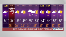
A cooler day to finish up the weekend but a better one than Monday. A frontal boundary keeps pushing south, plummeting our temperatures and bringing down wind chills in the 20s to the teens.
By Monday morning, our wind chills could drop as low as the single digits and a few sub-zeros will pop up far in the mountains. Some light snow will also continue to appear, stretching from the mountains and marching down to Massachusetts overnight. Even eastern Massachusetts could see some snow, Boston could have a few flurries before sunrise and Cape Cod could see some wintry precipitation as well in the first hours.
STAY IN THE KNOW
Watch NBC10 Boston news for free, 24/7, wherever you are. |
|
Get Boston local news, weather forecasts, lifestyle and entertainment stories to your inbox. Sign up for NBC Boston’s newsletters. |
Blustery conditions and mostly cloudy skies will take over Monday, making it the least favorite "spring" day for many. Scattered snow will remain a chance Monday.
Temperatures make an effort to rise to the upper 30s Tuesday thanks to the sunny skies. With a different sun angle than in winter, the sun will actually feel nicer. But the wind remains somewhat active on Tuesday for which temperatures will still feel relatively cool.
Get top local stories in Boston delivered to you every morning. Sign up for NBC Boston's News Headlines newsletter.
A warmer improvement arrives on Wednesday. This is when we see temperatures rise to the 40s and make a good climb to the 60s by the end of the week.
Rain chances come along with this southwest flow and allow for more moisture to fill in. The showers appear Thursday and spread into Friday morning, but even with a wet start, Friday will feature a sunny afternoon.