
An upper level system will be our dominant feature this weekend as we deal with some passing rain/snow showers and a few rumbles of thunder, especially Saturday evening into the first half of the night.
A few of these showers may contain some small hail and graupel. Graupel? Yes, graupel! Graupel is in the frozen precipitation family and is formed by supercooled water droplets collecting on snowflakes as they fall from the cold, upper levels of the atmosphere into a very shallow "relatively" mild surface layer causing them to partially melt. They are very distinct looking and can be mistaken for small hail, except graupel is white and has a crunchy texture.
STAY IN THE KNOW
Watch NBC10 Boston news for free, 24/7, wherever you are. |
|
Get Boston local news, weather forecasts, lifestyle and entertainment stories to your inbox. Sign up for NBC Boston’s newsletters. |
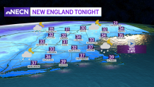
The threat for precipitation will be with us through the first half of the night and then we’ll see conditions improving. Lows Saturday night will dip into the upper 20s to mid 30s north and mid to upper 30s south.
Get top local stories in Boston delivered to you every morning. Sign up for NBC Boston's News Headlines newsletter.
We’ll still be dealing with the upper level system Sunday, but we're not expecting too much in the way of precipitation except for a few rain/snow showers across inland locations of southern New England and mainly snow showers across the mountains north.
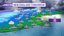
Clouds will be more dominant during the afternoon and a stray shower still can’t be ruled out for much of the area, but most will remain dry. Highs reach the upper 40s to 50 south and 30s and 40s north.
A strong cold front will pass through the region Sunday night with a few flurries and snow showers to go along with it.
Local
In-depth news coverage of the Greater Boston Area.


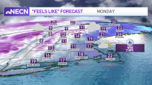
Much colder air will be in place with gusty northwest winds by the time Monday morning rolls around, with wind chill values reaching the single digits and teens, which is why we have added a First Alert stamp on our 10-Day Forecast!
Highs on Monday will barely make it into the upper 20s to low 30s north and mid 30s south!
The good news is the unseasonably cold temps will be short lived, with temperatures moderating back up to seasonable levels by the middle of next week, but that comes with the threat for more rain showers as we start the month of April.