
Our weather pattern this week stays active with little systems clipping near or across the northeast every other day or so. Colder air dominates the week for the most part, with a little brief warm up Wednesday into Thursday.
Today our temps will be in the 30s, with colder air slowly returning from the northwest. The breeze picks up a bit late today and temps fall to the low 30s and upper 20s by evening.
STAY IN THE KNOW
Watch NBC10 Boston news for free, 24/7, wherever you are. |
|
Get Boston local news, weather forecasts, lifestyle and entertainment stories to your inbox. Sign up for NBC Boston’s newsletters. |
Overnight lows drop to the teens and 20s with wind chills around 10-20 degrees. Ocean-effect showers or flurries continue across the outer Cape & Islands through evening and mountain snow showers (upslope snow) continue through Wednesday with minor accumulations.
Get top local stories in Boston delivered to you every morning. Sign up for NBC Boston's News Headlines newsletter.
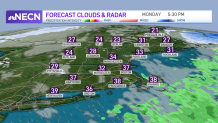
A weak system heads in for Tuesday. While this will increase our cloud cover and keep temps cool in the 30s, we don’t anticipate much in terms of precipitation. An isolated shower or snow shower north is possible.
Wednesday into Thursday our temps warm just a bit, so looking at 40s Wednesday and low 50s far south on Thursday. Another low pressure system moves through Thursday, brining rain showers south and snow showers north. Then we turn colder and windier Friday with highs back in the 30s.
Our active pattern remains as another low pressure system heads in Saturday. Again this one brings us rain showers south and snow north and west. Highs stay in the 30s both days this weekend, and we dry off for Sunday.