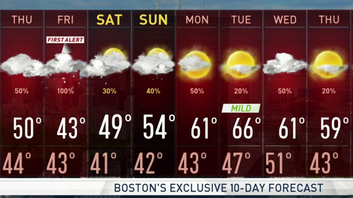
This Evening: Showers continue to fill in. Temps around 50. Overnight Thursday Night: Rain, fog, high terrain and far north/west. Lows in the 40s south, 30s north/west. Friday: Rain east, snow north/west. Gusty and blustery. Highs around 40.
The weather pendulum is swinging back hard toward a wintry pattern here in the northeast.
Our old slow-moving weather systems are finally moving a bit. That upper level low to our east is making way for the upper level low that was to our west. Rain has finally arrived in western New England.
Rain is only slowly progressing to the east, so we have sunshine in Maine. Otherwise clouds are increasing with showers arriving in the Boston area by 4 p.m. if not sooner. Temperatures are holding close to 50°.
There is a new storm center developing off the coast of New Jersey today. It’s going to intensify rapidly tonight, bringing heavy rain to portions of New England by evening and for most of the night.
Get Boston local news, weather forecasts, lifestyle and entertainment stories to your inbox. Sign up for NBC Boston’s newsletters.
At the same time - the air up in the sky is becoming colder, and we have rain changing to snow before midnight in the mountains of western New England.
The snow level is going to come down in elevation, perhaps all the way to the valley floors by morning. It’s a nearly impossible forecast, to try and predict where the rain/snow line is going to end up tomorrow.
The ocean water temperature is in the 40s and wind is coming in off of the water gusting past 40 mph from the northeast. That makes it challenging to get cold enough for snow anywhere near the coast. However, as the wind becomes more north to south, colder air may penetrate all the way to the Boston area.
It’s almost a coin toss whether we're going to have a rainstorm or a snowstorm in Boston.
The confidence is high that we will get a serious elevation snowstorm. Portions of the Berkshires, the Green Mountains and the Mount Monadnock area of New Hampshire are looking at double-digit snowfall. It’s a heavy wet snow and leaves are coming out on the trees, so we’re going to have power outages.
Once we get down in elevation to about 500 to 1,000 feet, where we have many towns in New England, we may see six or more inches of heavy wet snow, also capable of causing branches to break and power outages, even in some lower elevations.
If it was an all rain storm, we would be talking about one to three inches of rain.
Low pressure is going to move to Cape Cod and then stall during the day tomorrow, keeping the precipitation going for many through the day, and perhaps even into Saturday.
Wind from the northeast may gust past 40 mph along the coast from Boston to Portsmouth, New Hampshire and Portland, Maine. Some coastal erosion will be possible at high tide.
With the center of the storm over the Massachusetts Bay, the wind may come from the southwest on Cape Cod. That means temperatures could push into the 50s with the possibility of a little sunshine tomorrow.
So it looks like the highest impact will hit us tonight and much of the day tomorrow. But the storm only slowly weakens and eases off into the ocean tomorrow night and Saturday.
We will have plenty of leftover moisture with a lot of clouds and some mixed precipitation possible through Saturday morning. We should get break of sun by Saturday afternoon, at least near the shore, even as rain or snow showers continue in the mountains. High temperatures on Saturday will be mostly in the 40s.
One place that may escape the storm is central and northern Maine, where less precipitation is forecast.
Sunday looks like a mix of sun and clouds with a chance of a few showers. High temperatures will get back up into the 50s, 40s in the hills.
There’s also a snow storm happening in the western United States. We'll have to watch that as it moves to the east.
It’s a very active weather pattern and although we warm up a little early next week, it may get cold enough for some more snow or rain in our region again by the middle and second half of next week. It’s a very busy first alert 10 day forecast.