
-
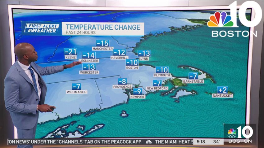
Where are the spring temperatues?
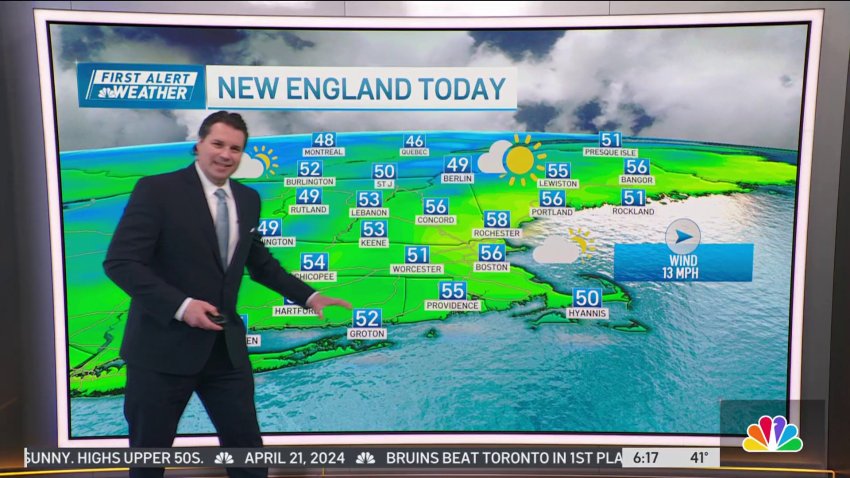
Today (Thursday): Chilly and dry day. Highs near 53 degrees.
Overnight Tonight: Clear skies. Lows near 30 degrees.
Friday: Cool but sunny. Highs near 55 degrees.
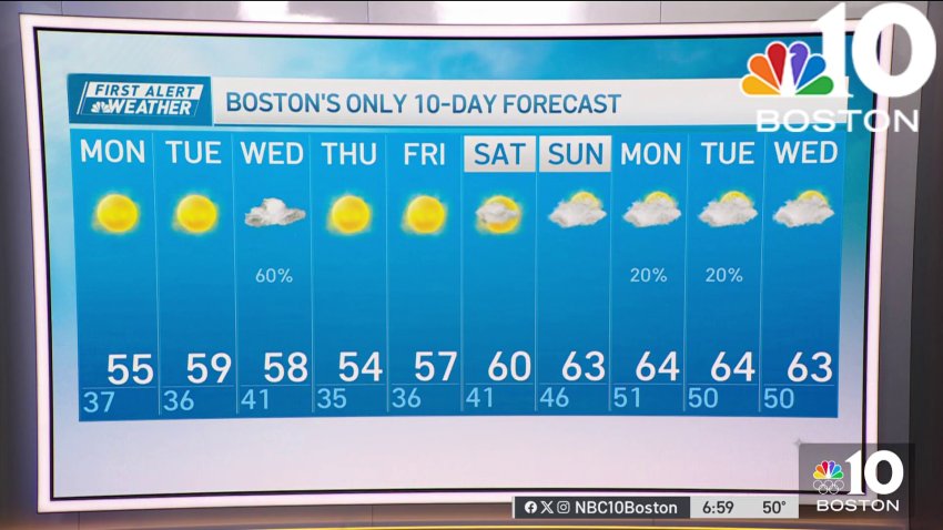
Saturday: Sunny. Highs near 63 degrees.Follow NBC10 Boston on…
Instagram: instagram.com/nbc10boston
TikTok: tiktok.com/@nbc10boston
Facebook: facebook.com/NBC10Boston
X: twitter.com/NBC10Boston -
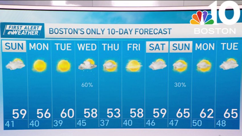
Forecast: Mostly nice week ahead
Today (Sunday): Morning sunshine, afternoon clouds dim out the sun, breezy. Highs upper 50s.
Overnight Tonight: Decreasing clouds, chilly, patchy frost. Lows in the 30s.
Monday: A frosty start, mostly sunny. Highs upper 50s.Follow NBC10 Boston on…
Instagram: instagram.com/nbc10boston
TikTok: tiktok.com/@nbc10boston
Facebook: facebook.com/NBC10Boston
X: twitter.com/NBC10Boston -
Cloudy and dry conditions on Sunday, patchy frost overnight
Overall, the upcoming week will be on the dry side with mild days and chilly nights.
-
Clouds dim otherwise Sunny Sunday afternoon
Today (Sunday): Morning sunshine, afternoon clouds dim out the sun, breezy. Highs upper 50s. Overnight Tonight: Decreasing clouds, chilly, patchy frost. Lows in the 30s. Monday: A frosty start, mostly sunny. Highs upper 50s.
-
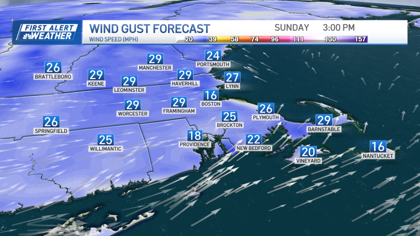
More sunshine hits New England as light showers roll in mid-week
Sunday will be the pick of the weekend, with morning sunshine on tap. On Sunday afternoon and evening, some clouds will build, and winds become a bit gusty. High temperatures will be mild in the upper 50s. New England will be greeted by more sunshine Monday and Tuesday with highs in the upper 50s to low 60s and nighttime lows…
-
Sunny afternoon leads into chilly Sunday night
Today (Sunday): Morning sunshine, afternoon clouds dim out the sun, breezy. Highs upper 50s. Overnight Tonight: Decreasing clouds, chilly, patchy frost. Lows in the 30s. Monday: A frosty start, mostly sunny. Highs upper 50s.
-
More sunshine hits New England as light showers roll in mid-week
Sunday will be the pick of the weekend, with morning sunshine on tap. On Sunday afternoon and evening, some clouds will build, and winds become a bit gusty. High temperatures will be mild in the upper 50s....
...New England will be greeted by more sunshine Monday and Tuesday with highs in the upper 50s to low 60s and nighttime lows in...
-
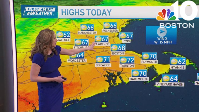
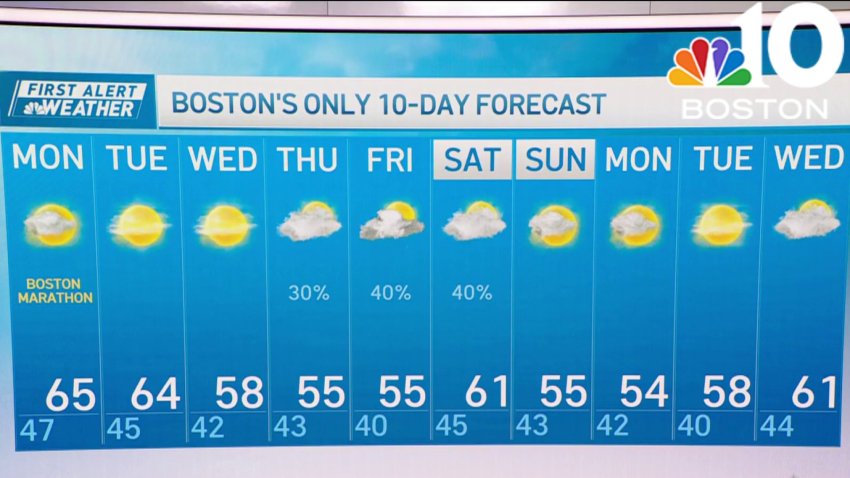
Sunny and warm for the Boston Marathon
Monday: Sunny and warm for the Boston Marathon. Highs in the mid 60s. W wind 5-15 mph.
Overnight: Clear with lows in the mid 40s.
Tuesday: Sunny with highs in the mid to upper 60s. West wind 10-15 mph.
Wednesday: Mostly sunny. Sea breezes. Highs in the 60s inland, 50s at the coast. -
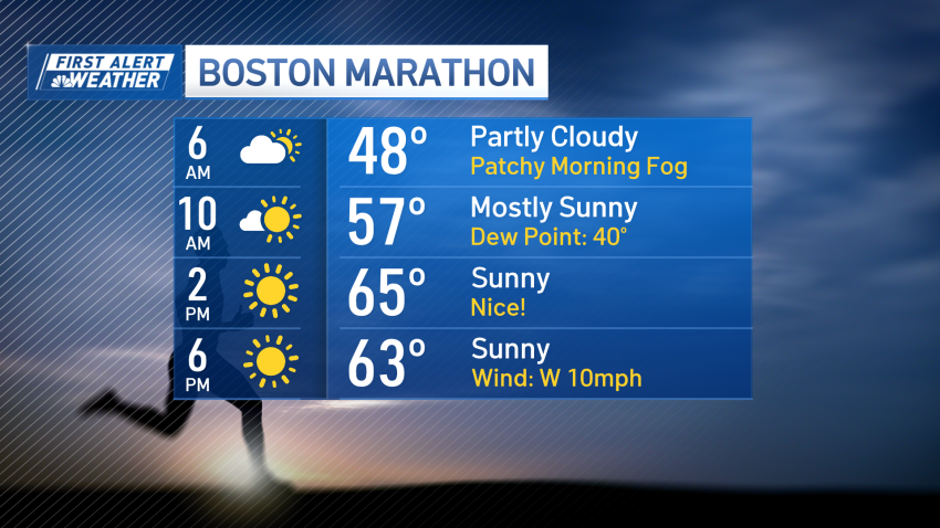
Sunny skies and warm weather for the 128th Boston Marathon
What a way to start spring break and a pleasant marathon morning! The afternoon will be a tad warmer than ideal for runners, but gorgeous for spectators — highs in the mid-60s with sunny skies. Tuesday will look like a copy and paste of Monday, with highs in the mid-60s and bright skies. Take advantage of these two days...
-
Sunny skies and warm temperatures ahead for the 128th Boston Marathon
Follow NBC10 Boston on…
Instagram: instagram.com/nbc10boston
TikTok: tiktok.com/@nbc10boston
Facebook: facebook.com/NBC10Boston
X: twitter.com/NBC10Boston -
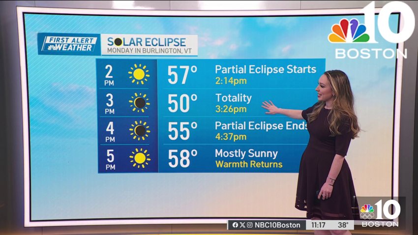
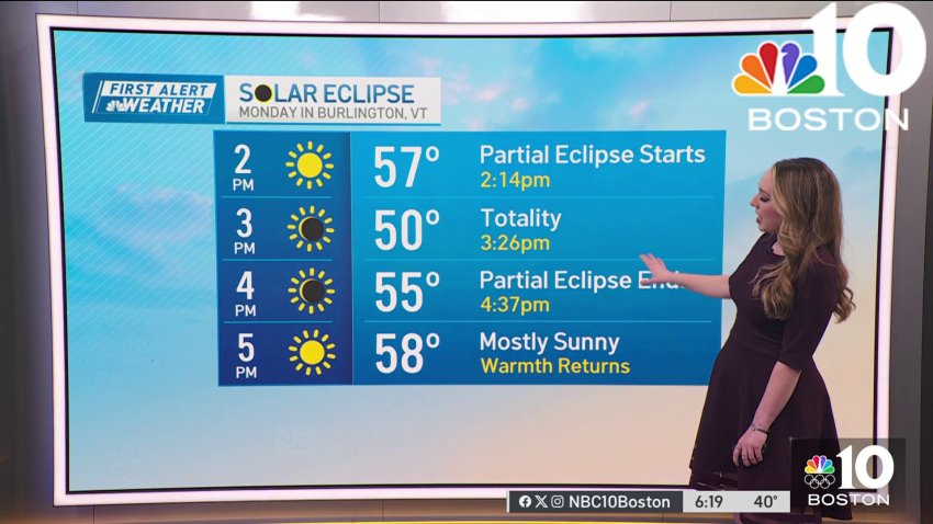
What will weather be for Monday's solar eclipse?
Overnight Tonight: Mostly cloudy, breezy with scattered rain/snow showers coast. Lows mid 30s.
Sunday: Clouds and sun, breezy, a morning snow/rain shower coast. Highs low to mid 40s.Follow NBC10 Boston on…
Instagram: instagram.com/nbc10boston
TikTok: tiktok.com/@nbc10boston
Facebook: facebook.com/NBC10Boston
X: twitter.com/NBC10Boston -
Forecast: Looking ahead to Monday's weather
Today: Mostly cloudy, breezy, few rain/snow showers coast. Highs low to mid 40s....
...
Overnight Tonight: Mostly cloudy, breezy with scattered rain/snow showers coast. Lows mid 30s....
Sunday: Clouds and sun, breezy, a morning snow/rain shower coast. Highs low to mid 40s....Follow NBC10 Boston on…...
Instagram: instagram.com/nbc10boston...
TikTok: tiktok.com/@nbc10boston...
Facebook: facebook.com/NBC10Boston...
X:... -
Weather forecast: Snow expected this week
Monday night: Dry night. Lows in the upper 30s. Tuesday: Cloudy skies, on shore wind. Highs in the 40s. Wednesday: First Alert. Morning sprinkles. Afternoon showers. Highs in the low 40s. Thursday: First Alert. Rain continues. Winds gust 30-40 mph with the chance for morning coastal flooding.
-
Weather forecast: Chance of snow ahead
Monday night: Dry night. Lows in the upper 30s. Tuesday: Cloudy skies, on shore wind. Highs in the 40s. Wednesday: First Alert. Morning sprinkles. Afternoon showers. Highs in the low 40s. Thursday: First Alert. Rain continues. Winds gust 30-40 mph with the chance for morning coastal flooding.
-
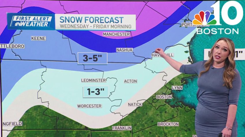
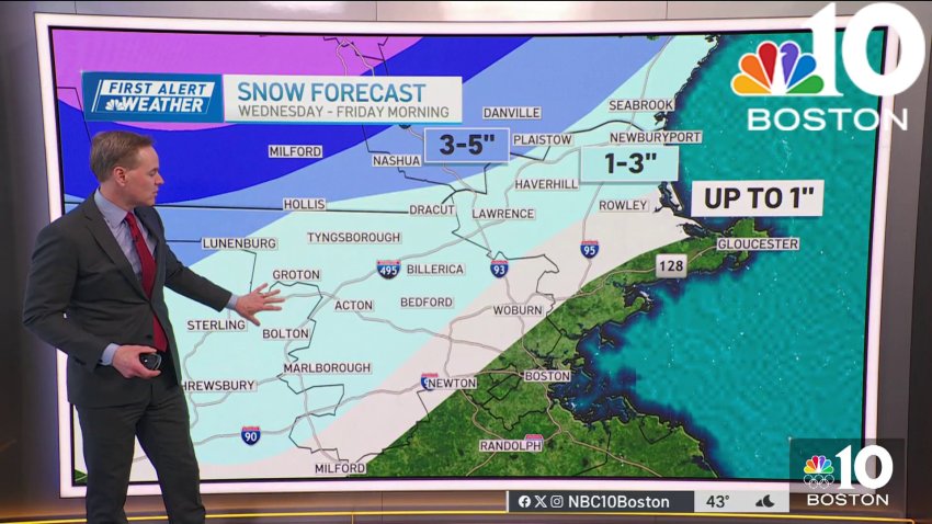
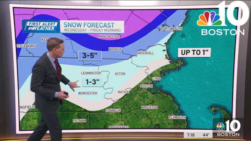
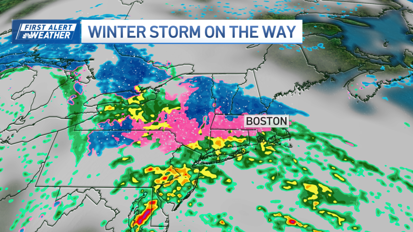
Rain — and snow? — headed to the Boston area this week | Latest storm forecast
Up to 5 inches of snow are possible from a winter storm headed to the Greater Boston area — here’s what we know right now, as a rainy stretch looms....
...Overnight Monday night: Dry night. Lows in the upper 30s. Tuesday: Cloudy skies, on shore wind. Highs in the 40s. Wednesday: First Alert Day. Morning sprinkles. Afternoon showers. Highs in the...
-
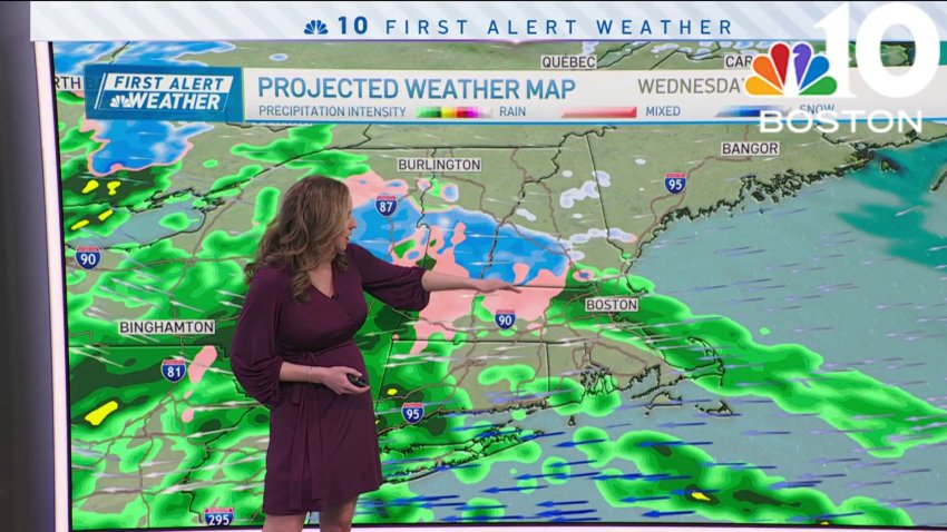
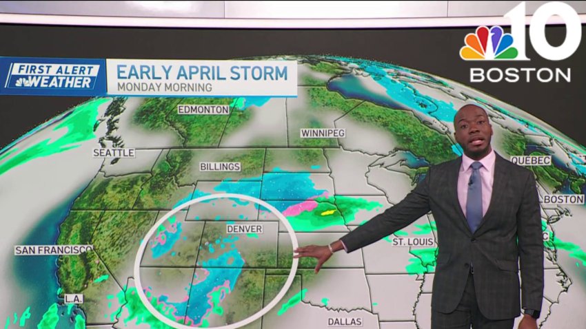
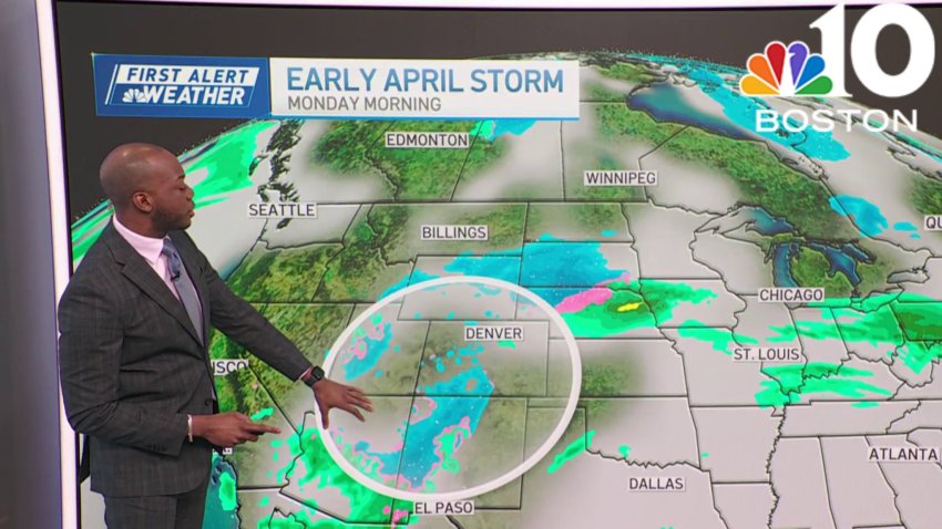
Mid-week winter storm to bring heavy rain and snow to region
Monday: Sun and clouds. Warmer. Highs in the mid 50s.
Overnight Monday night: Dry night. Lows in the upper 30s.
Tuesday: Cloudy skies, on shore wind. Highs in the 40s.
Wednesday: First Alert Day. Morning sprinkles. Afternoon showers. Highs in the low 40s. -
Messy early April nor'easter to bring heavy rain, sleet, snow to Mass., NH
We’re staring down one last tranquil weather day before our weather drastically changes. We’re in and out of the clouds Monday, but they should let up around 2 p.m. This will be around the peak heating of the day, so high temperatures approach 60 degrees. Throughout Monday night, a weaker weather system to our south will bring clouds back...
-
Mild Monday in Boston, with temps in the mid-50s
Monday: Sun and clouds. Warmer. Highs in the mid 50s.
Overnight Monday night: Dry night. Lows in the upper 30s.
Tuesday: Cloudy skies, on shore wind. Highs in the 40s.
Wednesday: First Alert Day. Morning sprinkles. Afternoon showers. Highs in the low 40s. -
Monday is one of the better outdoor days of the week
Monday: Partially cloudy skies with highs in the 50s.
-
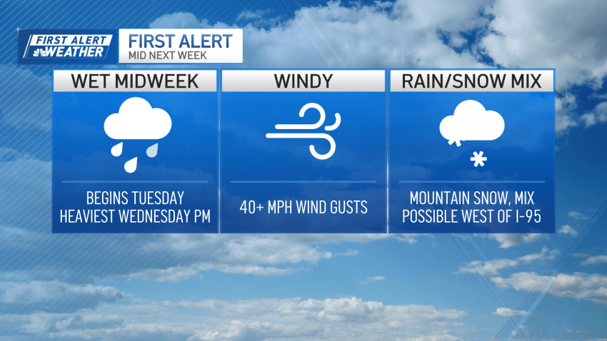
Mid-week storm brings heavy rain and wind gusts to Boston
Monday is one of the better outdoor days of the week. The start of the week looks mostly cloudy and mild, with highs reaching the upper 40s to low 50s. There may be a passing shower, but that is the exception and not the rule. However, things will start to change on Tuesday as a wet spell begins. While there…
Trending
