


Overnight Monday Night: Some wispy clouds. Lows in the 50s.
Tuesday: Sun & clouds. Highs near 80, 70s coast.
Monday evening, we keep the pleasant air around with temperatures in the 60s to around 70 and a near calm breeze.
A few wispy clouds pass by through later. We will have another cool night in store with lows dropping into the 50s for most, 40s across the north country. A stationary front is just to our north, but it slides across central New England for Tuesday.
Once the stationary front heads into New England on Tuesday, our temperatures will vary depending on where you live. Highs will be in the low 70s across Maine on the northern edge of that boundary, while southern New England will be in the low 80s inland, with local seabreezes keeping temperatures in the mid 70s on the coast. Our clouds will increase, and this front may trigger a couple of showers, but most of us stay dry.
We clear out again for Tuesday night into Wednesday, but more clouds head in by Wednesday afternoon. Highs reach the low 80s with more humid air transported our way up the eastern coast, so we may have to deal with drizzle and fog this day.
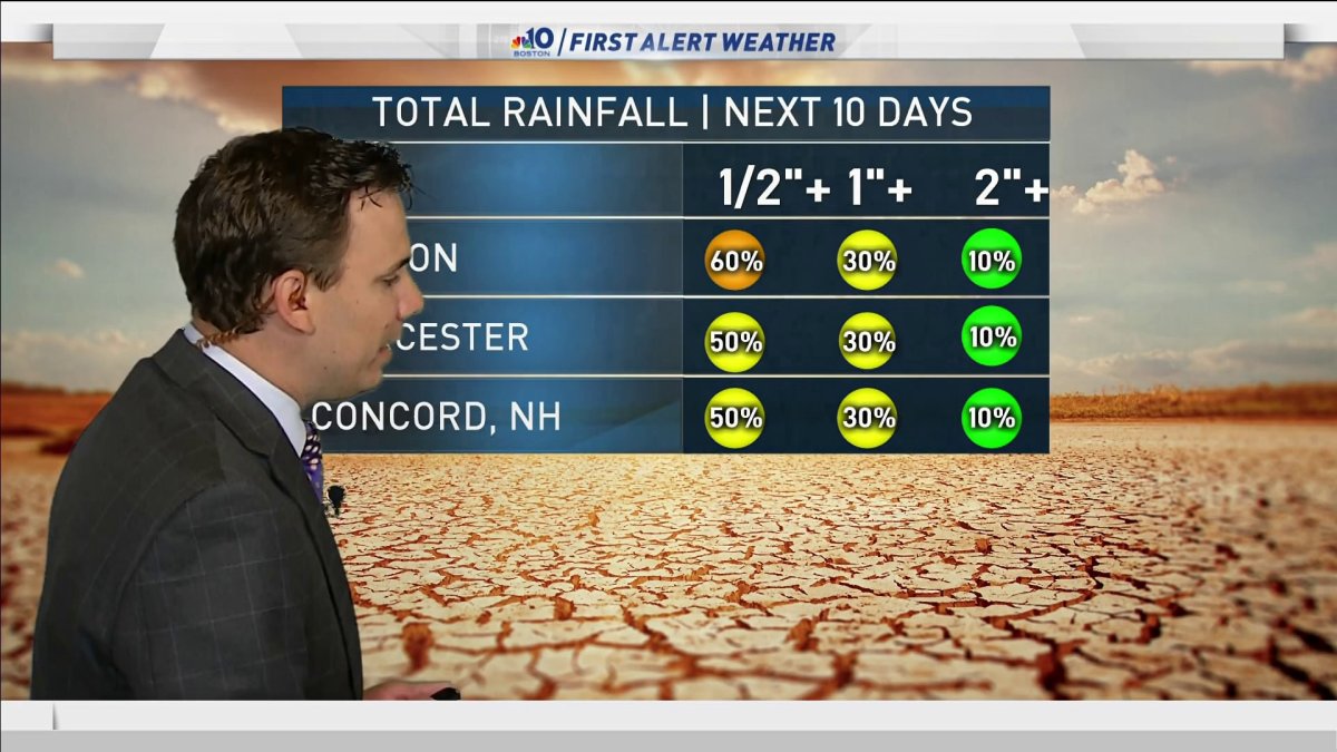
We really don't have a ton of rain in the forecast this week, which means our rain deficit continues from the spring. So far, for June, Boston is 0.68 inches under normal for rainfall. During meteorological spring, we ended up at 1.27 inches below normal for the months of March, April and May. April was the only month we were above normal.
Cristobal Coverage


A large area of low pressure will track across the Great Lakes and will absorb the leftovers of Cristobal over the next couple days. The system arrives in the northeast for Thursday, and will swing in a cold front, but the front may stall right over us through the weekend. So the heat and humidity will stick around through perhaps the weekend.
Right now, Friday looks to bring us a brief break from the intense humidity and rain. Scattered showers are likely Thursday, then again Saturday and Sunday with a few storms, too. Highs will be in the 70s to low 80s through the weekend. Stay tuned!

