
-
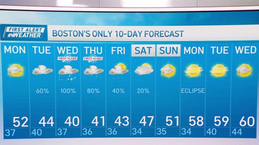
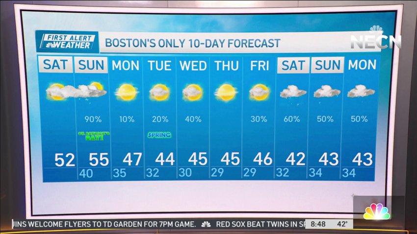
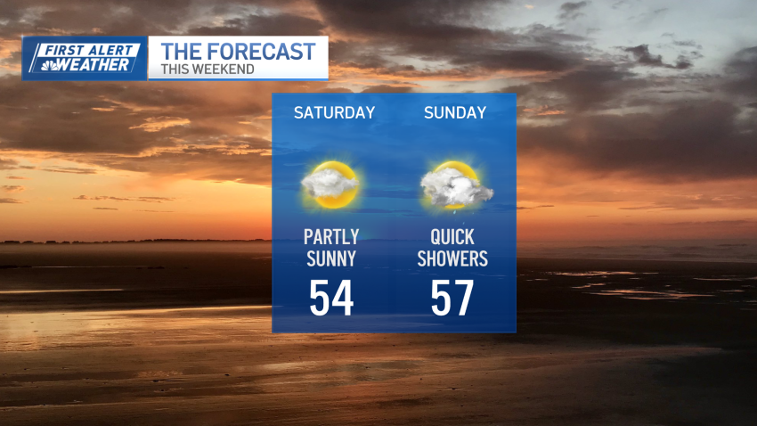
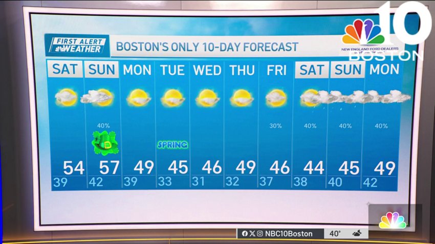
Light showers and sunny skies ahead in Boston
Boston’s 10-day forecast shows there are light showers and sunny skies ahead
-
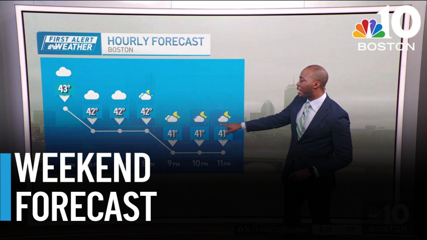
Dry, blustery conditions to start work week
Tonight: Mostly clear to partly cloudy. Low in the 20s in the suburbs, 30s on Cape Cod.
Monday: Sun and a few clouds. Breezy, gusts to 30 mph, 40 mph on Cape Cod. Highs around 40, wind chill near 30.
Follow NBC10 Boston on…Instagram: instagram.com/nbc10boston
TikTok: tiktok.com/@nbc10boston
Facebook: facebook.com/NBC10Boston
X: twitter.com/NBC10Boston -
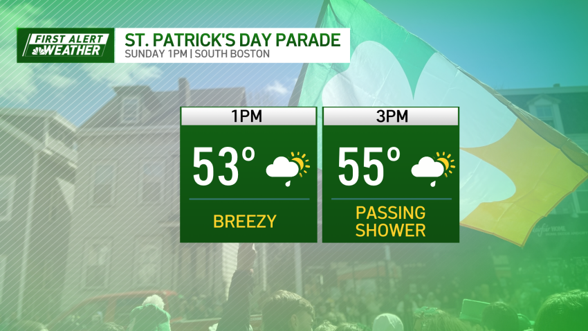
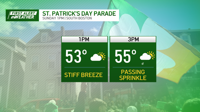
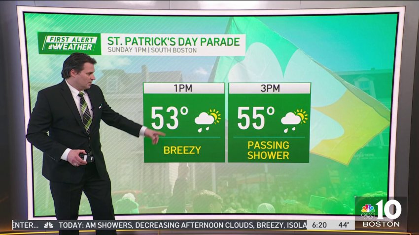
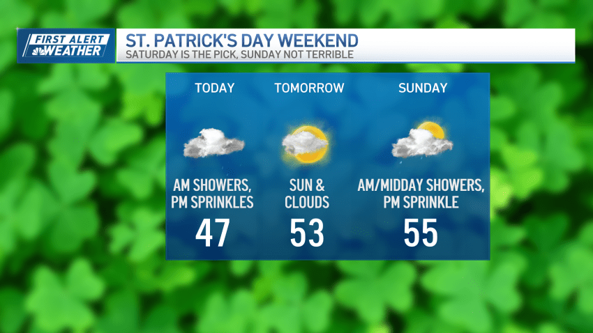
Mostly clear St. Patrick's Day before a cooler week ahead
Other than a gusty west wind, the St. Paddy’s Day Parade in Southie should go off as planned, but watch out for a stray shower/sprinkle through the mid-afternoon.
-
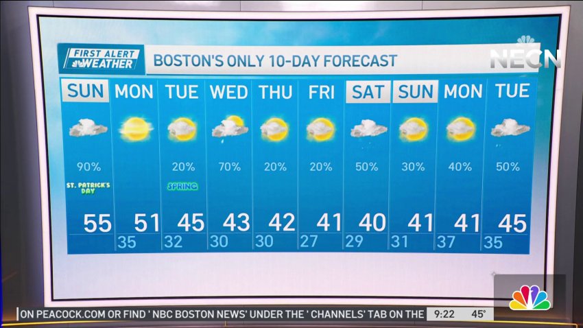
Week ahead stays cool after St. Patrick's Day
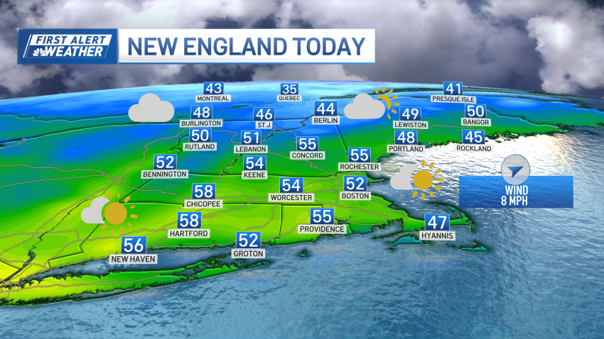
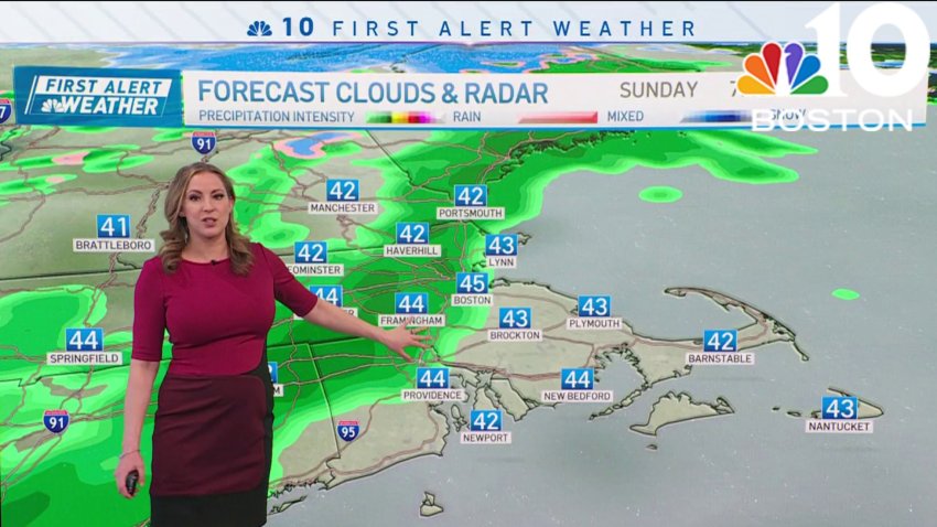
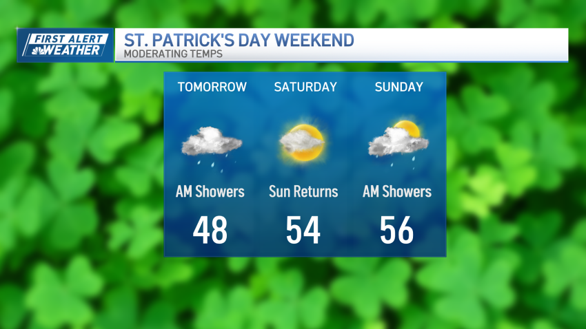
Today (Sunday): AM showers, decreasing afternoon clouds, breezy, isolated shower/sprinkle. Highs in the 50s. Overnight Tonight: Few clouds, breezy, and chilly. Lows low to mid 30s. Monday: AM sunshine, some afternoon clouds, breezy. Highs upper 40s to low 50s.
-
Mostly clear and breezy St. Patrick's Day
A sprinkle or two possible during the parade, but it will not be washed out by any means.
-
Breezy St. Patrick's Day in Boston
Today (Sunday): AM showers, decreasing afternoon clouds, breezy, isolated shower/sprinkle. Highs in the 50s. Overnight Tonight: Few clouds, breezy, and chilly. Lows low to mid 30s. Monday: AM sunshine, some afternoon clouds, breezy. Highs upper 40s to low 50s.
-
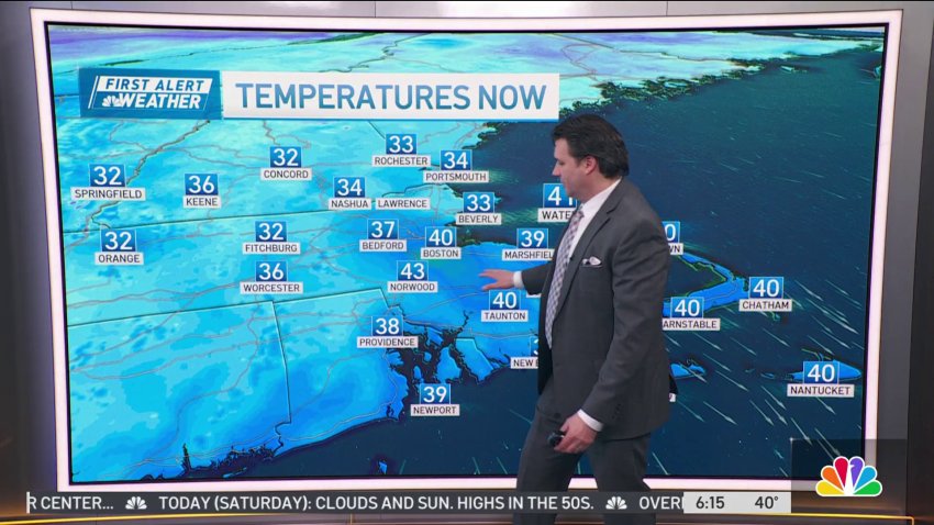
Sunny Saturday before fog and drizzle overnight
By the afternoon, the front will clear the coast leaving behind some clouds which may produce a quick sprinkle or shower, but those will be few and far between.
-
Sunny Saturday before some passing rain on Sunday morning
Today (Saturday): Clouds and sun. Highs in the 50s. Overnight Tonight: Mostly cloudy, patchy fog, showers by daybreak. Lows in the 30s. Sunday: AM showers, decreasing afternoon clouds, stray shower/sprinkle, breezy. Highs in the 50s.
-
Kicking off the weekend with a sunny Saturday
The parade in Soutie should be mostly dry, with just a slight chance at a passing shower.
-
Starting off the weekend with sunshine on Saturday
Today (Saturday): Clouds and sun. Highs in the 50s. Overnight Tonight: Mostly cloudy, patchy fog, showers by daybreak. Lows in the 30s. Sunday: AM showers, decreasing afternoon clouds, stray shower/sprinkle, breezy. Highs in the 50s.
-
Weather forecast: Highs in the 50s
Friday night: Gradual clearing. Lows in the 30s. Saturday: Sun and clouds. Highs in the 50s. Sunday: Morning and midday showers, chance afternoon sprinkle/shower. Breezy. Highs in the 50s.
-
Weather forecast: Lows in the 30s
Friday night: Gradual clearing. Lows in the 30s. Saturday: Sun and clouds. Highs in the 50s. Sunday: Morning and midday showers, chance afternoon sprinkle/shower. Breezy. Highs in the 50s.
-
Cloudy but dry Saturday, but rain possible on St. Patrick's Day
This Evening: Couple showers, cloudy. Temps in the 40s....
...
Overnight Tonight: Gradual clearing. Lows in the 30s....
Saturday: Sun and clouds. Highs in the 50s....
Sunday: AM and Midday showers, chance PM sprinkle/shower. Breezy. Highs in the 50s....Follow NBC10 Boston on…...
Instagram: instagram.com/nbc10boston...
TikTok: tiktok.com/@nbc10boston...
Facebook: facebook.com/NBC10Boston...
X:... -
When the rain will let up in Boston for St. Patrick's Day weekend
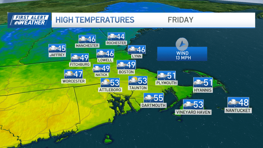
Friday: Occasional showers. Highs in the 40s for most. Overnight Friday night: Gradual clearing. Lows in the 30s. Saturday: Sun and clouds. Highs in the 50s. Sunday: AM and Midday showers, chance PM sprinkle/shower. Breezy. Highs in the 50s.
-
A little luck? St. Patrick's Day weekend brings more dry hours than wet
A showery Friday has seen the bulk of the showers focused in the morning hours, though a few, occasional showers will continue passing though our New England skies during the remainder of the day. A brief period of southerly winds able to bump temperatures into the 50s and even a few 60s south of the Massachusetts Turnpike is giving...
-
Off-and-on showers Friday; rain returns again on St. Pat's Day
Two fast-moving weather systems will zip through over the holiday weekend, and while we will be threatened by a few showers, it’s nowhere near washed out. Friday’s showers are already on their way out. Cloudy debris will remain behind, but in some spots across Central Massachusetts and Southern New Hampshire, we may see a few sunny breaks late day....
-
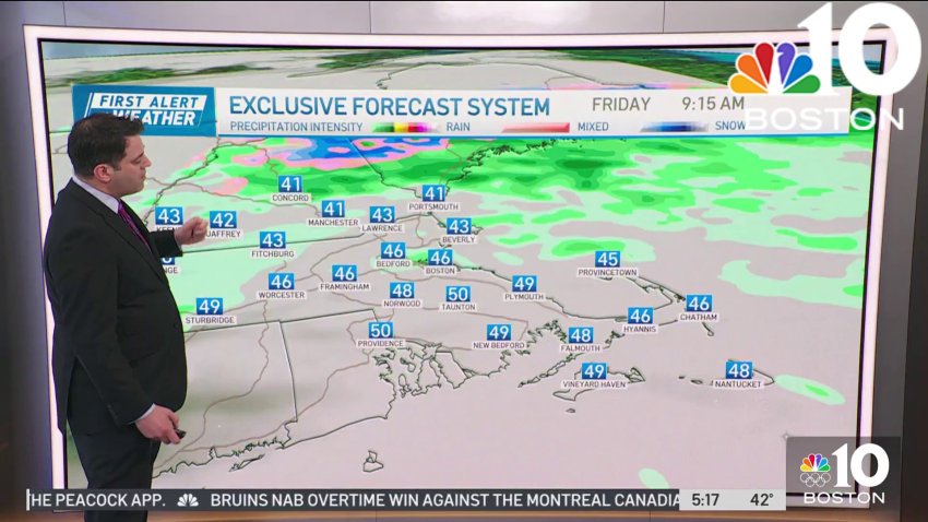
Forecast: Light rain Friday, showers return Sunday
Friday: Light morning rain to midday sprinkles. Highs in the mid-to-low 50s.
Saturday: Sun & clouds. Highs around 52°.Follow NBC10 Boston on…
Instagram: instagram.com/nbc10boston
TikTok: tiktok.com/@nbc10boston
Facebook: facebook.com/NBC10Boston
X: twitter.com/NBC10Boston -
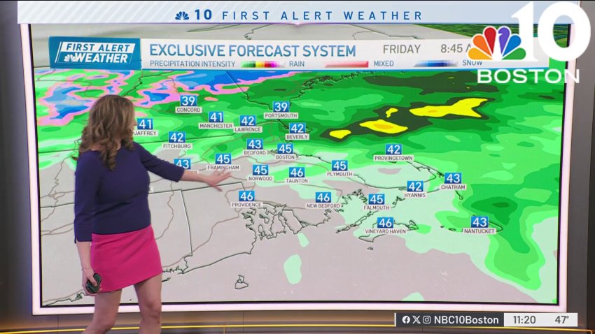
Forecast: Beautiful Thursday, but we're tracking return of rain
Today (Thursday): Sun and clouds, 60s inland, 50s coast with a sea breeze....
...
Overnight Tonight: Light rain after midnight. Lows around 40....
Friday: Light morning rain to midday showers, then a PM sprinkle. Highs in the 50s, 40s coast....
Saturday: Sun & clouds. Highs around 50....Follow NBC10 Boston on…...
Instagram: instagram.com/nbc10boston...
TikTok: tiktok.com/@nbc10boston...
Facebook: facebook.com/NBC10Boston...
X:... -

Milton pushes back against AG's MBTA zoning lawsuit
Attorney General Andrea Campbell and the Town of Milton are arguing over the MBTA Communities Law.
Follow NBC10 Boston on…
Instagram: instagram.com/nbc10boston
TikTok: tiktok.com/@nbc10boston
Facebook: facebook.com/NBC10Boston
X: twitter.com/NBC10Boston -
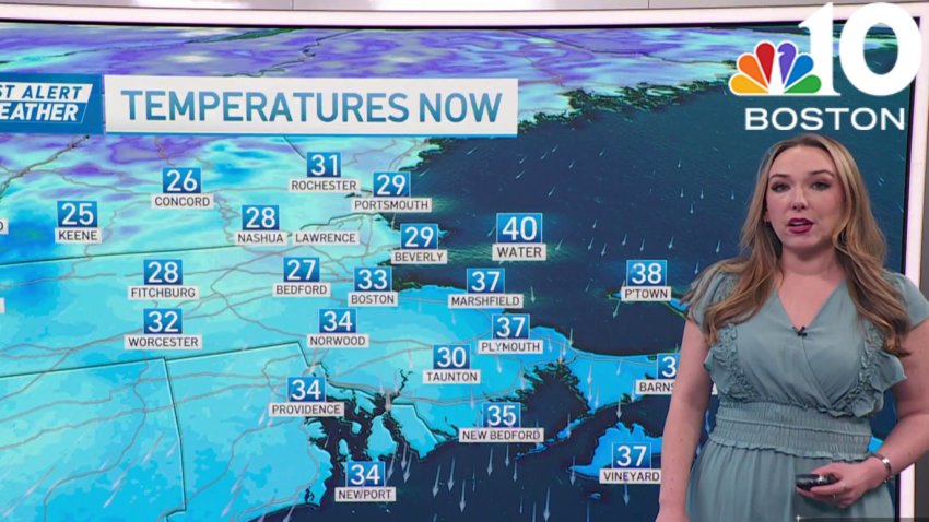
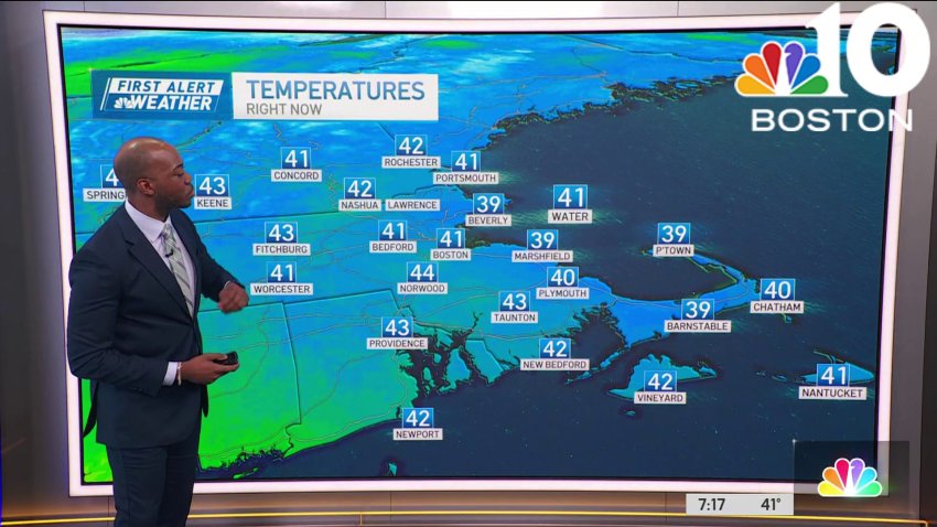
Parts of New England see 60s before rain moves in Thursday night
We’re basking in the spring warmth Thursday….but you have to be a good distance from the coast. Once again, Greater Worcester and parts of Southern New Hampshire come away with the gold as highs reach for the 60s. Meantime, the coast sees the sea breeze engage by mid-morning. Although the onshore winds are light, their impact will be to...
Trending
