
-

Partly cloudy Sunday in New England
Today (Sunday): A shower early Cape, very warm, isolated PM shower or storm . Highs mid to upper 80s. Overnight Tonight: Few clouds, comfortable. Lows mid to upper 60s. Monday: Mostly sunny early, some afternoon clouds, isolated PM shower. Highs low to mid 80s.
-

Warm and sunny Saturday to kick off the weekend
Today (Saturday): Mostly sunny this AM, high thin clouds this PM. Highs mid 80s. Overnight Tonight: Mostly cloudy, few showers. Lows mid to upper 60s. Sunday: Stray AM shower, increasing afternoon sun. Highs mid to upper 80s.
-

Sunny Sunday before very hot week in New England
Today (Sunday): Mostly sunny, hot, bit less humid, sea-breeze coast. Highs upper 80s to low 90s. Overnight Tonight: Few clouds, muggy. Lows low to mid 70s. Monday: Mosty sunny, hot, & humid, isolated PM storm. Highs low to mid 90s, heat index upper 90s to 100. Tuesday: Extremely hot & humid, isolated PM storm. Highs mid 90s, heat index 100+.
-

Mostly sunny and dry Sunday in New England
Today (Sunday): Mostly sunny, hot, bit less humid, sea-breeze coast. Highs upper 80s to low 90s. Overnight Tonight: Few clouds, muggy. Lows low to mid 70s. Monday: Mosty sunny, hot, & humid, isolated PM storm. Highs low to mid 90s, heat index upper 90s to 100. Tuesday: Extremely hot & humid, isolated PM storm. Highs mid 90s, heat index 100+.
-

Rain and thunderstorms in the region early Saturday
Today (Saturday): Downpours & t-storms this AM into early this PM, localized flooding. Highs mid 80s. Overnight Tonight: Few clouds, muggy. Lows low to mid 70s. Sunday: Mosty sunny, hot, slightly less humid, sea-breeze coast. Highs upper 80s to low 90s. Monday: Very hot & humid, isolated PM storm. Highs low to mid 90s.
-

Humid conditions to continue through the week
Today (Sunday): Hot and humid, clouds with breaks of sun, isolated PM storm. Highs upper 80s. Overnight Tonight: Partly cloudy, patchy fog, muggy. Lows low 70s. Monday: Hot and humid, partly cloudy. Highs upper 80s to 90. Tuesday: Partly cloudy, hot, and humid, isolated PM storms. Highs around 90.
-

Hot and humid weekend continues on Sunday
Today (Sunday): Hot and humid, clouds with breaks of sun, isolated PM storm. Highs upper 80s. Overnight Tonight: Partly cloudy, patchy fog, muggy. Lows low 70s. Monday: Hot and humid, partly cloudy. Highs upper 80s to 90. Tuesday: Partly cloudy, hot, and humid, isolated PM storms. Highs around 90.
-

Forecast: Sunny, hot and humid Sunday ahead
Overnight: Showers early, patchy fog, muggy. Lows low 70s. Sunday: More sunshine, hot and humid. Highs upper 80s. Monday: Hot and humid, hazy sunshine. Highs around 90.
Follow NBC10 Boston on…
Instagram: instagram.com/nbc10boston
TikTok: tiktok.com/@nbc10boston
Facebook: facebook.com/NBC10Boston
X: twitter.com/NBC10Boston -

Mostly cloudy skies with possible localized flooding on Saturday
Today (Saturday): Humid, clouds and sun, pop up storms, downpours, localized flooding. Highs mid 80s. Overnight Tonight: Showers early, patchy fog, muggy. Lows low 70s. Sunday: More sunshine, hot and humid. Highs upper 80s. Monday: Hot and humid, hazy sunshine. Highs around 90.
-

Scattered clouds during Fourth of July celebrations
Today (Thursday): Mostly Cloudy. Few Showers. High: 84 Overnight Tonight: Scattered Rain. Humid. Low: 67. Friday: Isolated Rain. Afternoon Sun. High: 84. Saturday: Morning Downpours. Partly Cloudy. High: 82.
-

Severe thunderstorm warnings in New England
The main threat with these storms will be damaging wind, hail, and heavy rain which may cause localized flooding, an isolated tornado is possible as well, timing will be between 1-2pm through around 9pm early tonight.
-

Hot and humid conditions bring severe weather risk on Sunday
Today (Sunday): Very warm and humid with PM storms, some severe with damaging wind & hail. Highs mid to upper 80s. Overnight Tonight: Scattered showers and storms early. Lows mid 60s. Monday: AM sunshine, building PM clouds, isolated shower, less humid. Highs mid to upper 70s. Tuesday: Mostly sunny, low humidity. Highs low 80s.
-

Warm and humid Sunday with possible storms ahead
Today (Sunday): Very warm and humid with PM storms, some severe with damaging wind & hail. Highs mid to upper 80s. Overnight Tonight: Scattered showers and storms early. Lows mid 60s. Monday: AM sunshine, building PM clouds, isolated shower, less humid. Highs mid to upper 70s. Tuesday: Mostly sunny, low humidity. Highs low 80s.
-

Clouds return to kick off weekend
Today (Saturday): Partly sunny, increasing humidity. Highs upper 70s. Overnight Tonight: Scattered showers and storms, muggy. Lows upper 60s. Sunday: Humid, very warm with a few AM showers, scattered PM storms, some severe with damaging wind & hail. Highs mid to upper 80s. Monday: Sun and clouds, isolated PM shower or storm. Highs upper 70s.
-

Severe storms and possible tornadoes in New England on Sunday
Today (Sunday): Hot, humid, Isolated Am showers and storms, scattered late PM storms, some severe. Highs upper 80s. Overnight Tonight: Scattered showers and storms early, some severe. Lows upper 60s to low 70s. Monday: Sunshine with afternoon clouds, isolated PM shower or storm. Highs mid 80s.
-

Hot and humid Sunday with possible tornadoes
Today (Sunday): Hot, humid, Isolated Am showers and storms, scattered late PM storms, some severe. Highs upper 80s.
-

Humid Saturday with possible storms in the afternoon
Today (Saturday): Mostly cloudy, muggy, afternoon shower and storms. Highs mid 70s. Overnight Tonight: Scattered showers and storms, patchy fog. Lows mid 60s. Sunday: Sun and clouds, scattered showers and storms. Highs mid to upper 80s. Monday: Clouds and sun, scattered showers and storms. Highs low 80s.
-

Possible storms on Saturday afternoon
Today (Saturday): Mostly cloudy, muggy, afternoon shower and storms. Highs mid 70s. Overnight Tonight: Scattered showers and storms, patchy fog. Lows mid 60s. Sunday: Sun and clouds, scattered showers and storms. Highs mid to upper 80s. Monday: Clouds and sun, scattered showers and storms. Highs low 80s.
-

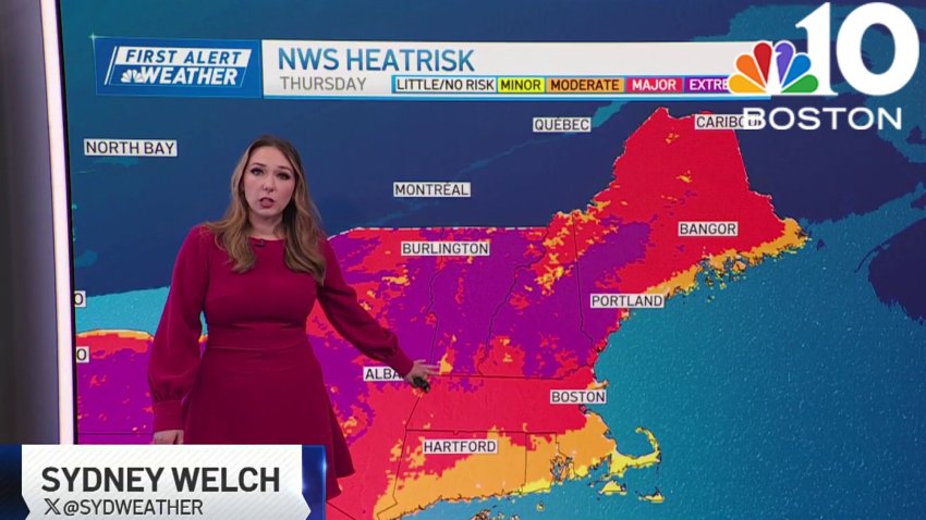
How heat will impact air quality in New England
A dome of heat will be settling over New England this week, building heat and humidity while affecting air quality. The Massachusetts Department of Environmental Protection has issued an air quality alert for ground-level ozone until 11 p.m. Tuesday. The alert points out the dual threats facing much of the region: Extreme heat and worsening air quality. These can pose…
-
Intense heat wave in Boston this week: details on the temperatures
Monday evening: Partly Cloudy. Dry. Temps in the low 80s.Overnight: Mild. Partly Cloudy. Low: 67.Tuesday: Hot & Dry. Sunny. High: 92. Wednesday: Hot & Humid. Partly Cloudy. High: 94.
Trending
