
Yesterday’s thaw is a distant memory as we await the coldest airmass of the season. It drops tonight with the passage of the arctic front and ushers in bitter air for Tuesday.
A shift in the jet stream has allowed the numbing air across the Upper Plains to dislodge and shift east to New England. After a late night snow shower or squall, the floodgates of cold will open.
STAY IN THE KNOW
Watch NBC10 Boston news for free, 24/7, wherever you are. |
|
Get Boston local news, weather forecasts, lifestyle and entertainment stories to your inbox. Sign up for NBC Boston’s newsletters. |
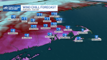
We’ll awake to steady winds and frigid temps in the single digits to low teens (below zero in northern New England). While the wind won’t be extreme, just a slight breeze with this air will cause wind chills to bottom out in the teens below zero. Cold like that won’t make ANY time outside pleasant.
Get top local stories in Boston delivered to you every morning. Sign up for NBC Boston's News Headlines newsletter.
Dress for the wind chill, not the air temp – which is respectably in the teens by afternoon. (OK, maybe it won’t get a lot of respect, but it’s better than single digit high temps).
Remarkably (or not for this ying-yang winter), the temperatures turn around quickly. You’d think with highs in the teens Tuesday that low temps Tuesday night would be well below zero. Not so.
Weather Stories


In fact, the numbers level off Tuesday night as the airmass begins to warm. We’re shooting for highs that not only surpass freezing Wednesday, but flirt with 40 degrees in spots!
We’re warming a bit more on Thursday as the winds continue from the southwest. We’ll dig a little deeper into the 40s before the door shuts on the mini-thaw Friday. Two storm systems – one Friday and one Sunday – will be nearby.
Friday could see some flakes (especially Cape Cod) and Sunday could see something more significant. With anything that far out, we’ll stay vigilant. In the meantime, don’t get caught in the cold.
Make it a good, safe week!