
High pressure over New England will provide us with mostly sunny conditions and colder than average temperatures as we close out the work week. We’ll also notice the wind picking up as we go through the afternoon and evening, which may make it feel a bit colder. Highs reach the low to mid 30s south and the 20s north.
Other than a some clouds across northern New England, which may produce a flurry or snow shower, much of the area should remain mostly clear overnight, with temperatures dropping off quickly across the interior and in the valleys. Lows dip into the teens across interior southern New England, the low 20s everywhere else, and single digits to mid-teens north.
WATCH ANYTIME FOR FREE
Stream NBC10 Boston news for free, 24/7, wherever you are. |
Saturday starts the warmup as winds turn more out of the south as high pressure shifts to our east, tapping into some of the warmth that has building across the deep south. Clouds will also be on the increase during the day, dimming out the sun by late in the afternoon. Highs reach the low 40s south and the 30s north.
A couple of rain/snow showers are possible south during the first portion of Saturday night as a warm front lifts through the region. To the north, we’ll likely see a period of snow overnight Saturday which will start to transition to rain showers Sunday morning as milder air surges into the region. A coating to an inch or so is possible there.
Get updates on what's happening in Boston to your inbox. Sign up for our News Headlines newsletter.
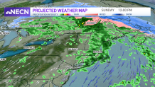
Very mild air replaces the cold Sunday, along with gusty southerly winds. We're also keeping the risk for showers in the forecast, especially Sunday afternoon. Highs reach the low 60s south and 50s north.
Beyond that, another system will bring more unsettled weather to the area Monday, but with colder air moving back into the region from the north, it looks like we’ll be seeing more snow across northern New England and mostly rain south. We’ll continue to monitor and fine tune that portion of the forecast as we get closer. Stay tuned!