
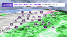
Freezing drizzle and freezing rain created problems on the roads Wednesday morning with light ice accumulation. Our temperatures eventually warm up enough to melt the ice away in southern New England, but watch for lingering slick spots in valleys that stay near 32 degrees in the afternoon.
Temperatures stay close enough to freezing in northern New England and in the mountains all day that a light wintry mix hangs around through evening. Temperatures in southern New England will reach the upper 40s to low 50s on a gusty south wind. Scattered rain continues through the early evening, heading offshore and off of Cape Cod after dinnertime.
WATCH ANYTIME FOR FREE
Stream NBC10 Boston news for free, 24/7, wherever you are. |
Thursday we have a break in storms as high pressure briefly takes over and the sky clears. Expect sunshine early in the day, with clouds rolling in by nightfall. Highs reach the upper 30s to lower 30s far north.
Get updates on what's happening in Boston to your inbox. Sign up for our News Headlines newsletter.
Friday brings in a winter storm and a First Alert day for snow. The forecast models are in agreement that we will see plowable snow for Boston and much of New England. We also see agreement on a quick moving storm, impacting the Friday morning commute the most.
We are uncertain on the track or where the rain/snow line will set up. This will affect our snow totals and who could see more snowfall versus rain. For now, several inches of snow are expected for Boston (4 to 6 inches, roughly), and 1 to 4 inches in northern and western New England.
Stay tuned for updates on this storm and snow totals. Any wobble in the track could have a significant impact on how much snow Boston will get.
The weekend is split with a cold and sunny day Saturday as highs stay in the 20s. On Sunday we jump into the low 40s with scattered rain showers.
Local
In-depth news coverage of the Greater Boston Area.


We see a signal of significant cold, especially around Tuesday, with some of the coldest temps this season. We'll have sun and dry weather through midweek.