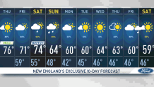
We have the last mid to upper 70s of the week on Thursday. We get to dress in shorts and a T-shirt while taking a walk by the park admiring the fall foliage.
We’ll continue with partly cloudy skies, with rays of sunshine making their statement and comfortable dew points. Enjoy it while you can, these temperatures will be changing Friday with a few degrees less and cloud-filled skies.
STAY IN THE KNOW
Watch NBC10 Boston news for free, 24/7, wherever you are. |
|
Get Boston local news, weather forecasts, lifestyle and entertainment stories to your inbox. Sign up for NBC Boston’s newsletters. |
A few pop-up showers and sprinkles are possible Thursday afternoon, but nothing significant. They’ll be isolated and leave quickly. Friday will be a mostly cloudy day with highs in the low 70s and a few spots topping out in the upper 60s.
As far as rainfall chances go, we’ll see most of the activity in Vermont, New Hampshire and northern Massachusetts Friday, with some evening pop-up showers entering western Massachusetts and returning east overnight.
Get top local stories in Boston delivered to you every morning. Sign up for NBC Boston's News Headlines newsletter.
Saturday isn’t looking too bad; it seems we’ll get some early morning showers that won't last long, allowing eastern New England to enjoy a dry lunch time and early afternoon, with rain entering eastern New England for the evening and overnight hours.
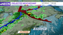
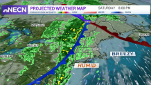
Sunday is looking good too, as most of the instability and moisture is likely to be out by noon. Sunday will also see a dip in temperatures, with highs coming down to the low to mid 60s and sunshine battling its way in again for the afternoon. Breezy conditions are expected with the passage of this cold front and will likely remain gusty for early Sunday with improving conditions later on in the day.
As far as next week goes, we’re starting off on the dry side at least until midweek. Temperatures remain in the low 60s, closer to normal values and showers return by the end of the week.