
String sun is contributing to the heat Sunday. We’ll see a sea breeze develop but we may rebound and possibly surpass the 90 degree mark, even in Boston.
The southern coast will be a different story. With the wind out of the south (10 to 20 mph), they will mostly see temperatures in the 80s. Dew points will also be in the mid 60s, making it feel more humid.
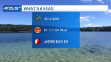
With these temperatures and plenty of sunshine, this is a perfect beach day. Expect cooler temperatures along the southeast beaches. A moderate risk for rip currents does remain along the North Shore beaches.
Get Boston local news, weather forecasts, lifestyle and entertainment stories to your inbox. Sign up for NBC Boston’s newsletters.
The summer heat is on across much of the region. Sunday is the hottest day of the weekend. Temperatures will soar into the 90s and even some mid 90s across the Merrimack and Connecticut valleys.
Overnight, we’ll see clouds increase due to a trough ahead of the cold front moving west to east. Therefore, showers and afternoon storms will impact our region. The greatest threat will be mid to late afternoon, impacting the evening commute. These showers and possible heavy rainfall may extend into Tuesday morning.
Tuesday and Wednesday will be dry, with abundant sunshine and seasonable temperatures around 80. By the latter part of the week, we’re seeing a warming trend into the holiday weekend, with an increased chance for unsettled weather and a chance for showers and storms. Monday, July 4th is looking quiet, with temperatures around 80.
Local
In-depth news coverage of the Greater Boston Area.


Please stay cool and hydrated on this hot summer day. Remember never to leave children or pets unattended in your car. Cars can heat up quickly and be dangerous.
In 90 degree air temperature, cars will heat up:
In 10 minutes: 109 degrees
In 30 minutes: 124 degrees
In 60 minutes: 133 degrees
Stay safe and enjoy this summer weather.
