
A weak system moves through overnight, bringing in nuisance precipitation. A wintry mix begins from west to east after dinnertime Monday and spreads across New England overnight.
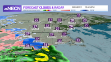
The precipitation fizzles out slowly by dawn Tuesday. A light glaze of ice will leave untreated surfaces slick, and untreated roads slippery. Light snow is expected to mix in the mountains through early Tuesday morning.
Get Boston local news, weather forecasts, lifestyle and entertainment stories to your inbox. Sign up for NBC Boston’s newsletters.
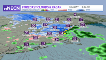
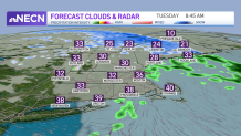
Temperatures rise slowly after midnight, so the wintry precipitation changes to a mix then rain south to north by morning. We dry out during the day, with interior Maine seeing lingering snow to a mix all afternoon.
Tuesday is dry with highs in the 40s, a tad milder than Monday. Another weak system moves through Tuesday night into Wednesday morning. This system doesn’t have a lot of lift or even a lot of cold air, so again we expect a light wintry mix overnight. In fact, most of the precipitation may miss us to the south as the system fizzles out as it nears the northeast.
Local
In-depth news coverage of the Greater Boston Area.


Another light mix is anticipated in the mountains during the day, amounting to a coating to 2 inches of a sloppy mess.
Clouds dominate again for Wednesday afternoon as this wave of energy is slow the exit. Highs will be in the mid to upper 30s as slightly cooler air returns for a short time.
Thursday brings us another system, giving us scattered rain showers and more clouds along with milder highs in the 40s. Friday seems to be our only totally dry day, with a mix of clouds and sun and highs in the low 40s.
New Year’s Eve festivities will be dry and quiet. There is a chance for some colder air to head in for the first few days of the new year.
Sometime this weekend we may get a more significant system moving through with some wintry weather, especially with the colder shot of air. Stay tuned!
