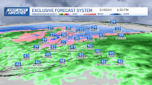
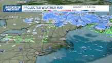
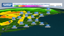
Low pressure develops south of New England on Sunday providing the region with moderate to heavy rain south and heavy snow north. Southern New England will deal with an east/northeast wind with rain, moderate to heavy at times, continuing into the overnight before tapering off.
About an inch of rain is expected with locally higher amounts possibly leading to some ponding in the roadways. Temperatures will remain steady in the mid 40s through this evening and drop off a bit overnight settling to around 40 along the coast, 30s inland.

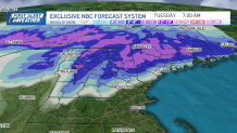
We’ll watch the higher terrain closely with cold air slowly funneling down into southern New Hampshire and northern Massachusetts, but expecting a sharp cut off in precipitation mitigating amounts. Meanwhile, in central and northern New England, winter weather advisories and winter storm warnings are up this afternoon through tomorrow.
Get Boston local news, weather forecasts, lifestyle and entertainment stories to your inbox. Sign up for NBC Boston’s newsletters.
Travel will become a bit tricky this afternoon across northernmost Vermont and New Hampshire and eventually Maine this evening where we area expecting a solid 6-8” of snow with over a foot possible across the highest terrain before ending Monday afternoon, which is featured on our in-house snow total map.

Low pressure pulls away during the day Monday with some leftover clouds, perhaps a stray shower/sprinkle south, but most stay on the dry side…snow ends north during the afternoon. Highs in the upper 40s, 30s north.
The forecast gets a bit tricky Tuesday and Wednesday with cold air spilling back into the region and a trough of low pressure swinging through eastern New England which may provide some snow and rain showers, especially along the coast. It really doesn’t look like too big of a deal, but we will see a few more clouds than previously forecasted.

Still some uncertainty with a clipper type system arriving Friday. Twenty four hours ago it was all systems go, now it looks like we’ll be a bit more tranquil later in the week with unsettled conditions arriving late next weekend along with milder temps.

Have a great rest of your weekend!

