First of all, Wednesday will feature more afternoon sunshine after some early morning rain and snow showers. Expect highs in the 20s and 30s across northern New England, with highs closer to 40 south.
New England is no stranger to piles of snow being dumped onto the region each winter. Take a look at some of the worst storms to hit in modern history.
Clouds will increase Wednesday night, with the first round of precipitation breaking out during the wee hours of Thursday morning.
During the Thursday morning commute, expect a wintry mix of rain, sleet, freezing rain, and snow in southern New England, with snow north. This will generally be fairly light, and we’ll flip to rain pretty quickly for areas near and south of Boston.
The change happens during the mid to late morning from the city northward toward the New Hampshire border.
During the afternoon, snow and a wintry mix continues, albeit lightly, across northern New England, with spotty rain showers in southern New England.
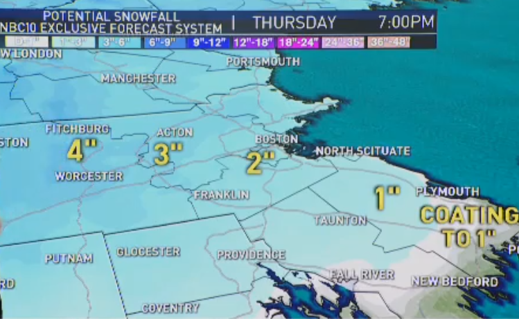
Friday brings the next round of precipitation. Temperatures will be warmer, near 50 around Boston, so this will fall as heavy rain in southern New England, and heavy snow in far northern New England.
Press Herald via Getty Images
SACO, ME - MARCH 14: Dan Littlefield of Campe Ellis attempts to clear snow from his car Sunday morning, March 14, 1993. "There was a car around here somewhere," he joked. The Portland Jetport received 17 inches of new snow during the previous day's blizzard. (Photo by David A. Rogers/Portland Press Herald via Getty Images)
Press Herald via Getty Images
Dan Littlefield of Campe Ellis attempts to clear snow from his car Sunday morning, March 14, 1993, in Saco, Maine. "There was a car around here somewhere," he joked. The Portland Jetport received 17 inches of new snow during the previous day's blizzard.
AP
In this March 14, 1993, file photo, cousins Allen, bottom, and Lauren Haywood, middle, and Aubrey Parsons, all from Washington, take advantage of the snowy hill in front of the Capitol in Washington, D.C. Dubbed the "Storm of the Century," the intense 1993 storm produced tremendous amounts of snow from Tennessee to the Canadian border, with many locations breaking snowfall records.
AP
Morning commuters negotiate their way over one of many walls of ice and snow that blocked street corners in New York's midtown Manhattan on March 15, 1993. Most of the secondary streets throughout the city were impassable from several inches of snow and ice.
AP
A homeless man wraps what clothes he has on around himself as he walks along Manhattan's Sixth Avenue after a winter storm brought the city to a standstill, March 14, 1993. Wind-driven snow blanketed the city and its suburbs closing airports, cutting off transportation systems and leaving midtown Manhattan mostly deserted.
AP
People walk past Radio City Music Hall along a snow covered street in New York on Jan. 7, 1996. A blizzard roared into the metropolitan area, dumping up to 2 inches of snow an hour that closed LaGuardia, Kennedy and Newark airports.
Boston Globe via Getty Images
Boston's City Hall Plaza saw only a few people passing through in the snow, as a blizzard caused a shut down of the city, Jan. 8, 1996.
Boston Globe via Getty Images
A man pulls children on a sled through Copley Square in Boston, Massachusetts, during a snowstorm, Jan. 8, 1996.
AP
In this Jan. 8, 1996, file photo, two cars remain buried in the snow as pedestrians walk on 21st Street in Philadelphia. A widespread blanket of 2 to 3 feet of snow fell from the Mid-Atlantic states to New England, including 30.7 inches in Philadelphia, the city's highest on record.
NY Daily News Archive via Getty Images
Trucks and a payloader dump snow into the frozen Schuylkill River, Jan. 9, 1996, as Philadelphia tries to dig out from a blizzard.
AP
In this Jan. 25, 2005, file photo, Sam Germaine, of Hull, Massachusetts, surveys ice formations on houses along the oceanfront, in Hull. The 2005 storm brought up to 3 feet of snow in southern New England, including 22.5 inches in Boston. Some areas around the city reported snowfall rates of 3 to 5 inches per hour and wind gusts up to 85 mph, leading to white-out conditions.
Boston Globe via Getty Images
Long-term parked vehicles at Logan Airport sit in snow plowed lanes on Jan. 24, 2005, after heavy blizzard snowfall hit the area.
Getty Images
Pedestrians work their way across the street during white-out conditions along the lakefront, Jan. 22, 2005, in Chicago, Illinois.
AP
In this Jan. 22, 2005, file photo, workers clear snow from the the Philadelphia Eagles' home field during a winter storm in preparation for the NFC championship game against the Atlanta Falcons.
Getty Images
John Long of Portland, Maine, enjoyed the snow Sunday morning as he walked along Baxter Blvd. in Portland, Sunday, Jan. 23, 2005. The magnitude of the storm did not seem to overly impress him as he said, "it is what it is."
Getty Images
A man waits for a taxi as a security guard walks past outside Penn Station, Jan. 22, 2005, in New York City.
AP
In this Feb. 17, 2003, file photo, Francis Miller shovels snow from his sidewalk into the street after a winter storm dumped two feet of snow in the area, in Baltimore. This storm on Presidents' Day weekend paralyzed an swath of the Northeast from Washington to Boston, producing the latter city's heaviest snowfall on record, a whopping 27.6 inches. The Baltimore area suffered the most, as more than 3 feet fell north of the city.
NY Daily News Archive via Getty Images
On the morning after the Blizzard of '03 dumped nearly 20 inches of snow on the city, a snowman with a low center of gravity is a memento of the storm on Seventh Ave. between 46th and 47th Streets, Feb. 18, 2003.
AP
In this Feb. 18, 2003, file photo, heavy seas crash against the Humarock section of Scituate, Massachusetts, during the noontime high tide on the day after a big winter storm dumped about two feet of snow in the Boston area.
Boston Globe via Getty Images
Sales people, general managers and even the owners at Expressway Motors Inc. in Dorchester, Massachusetts, had to clean and move automobiles since 7 a.m. at the auto dealership lot to clear them from snow left by the blizzard of February 2003. It was a tough President's Day for most Boston-area auto dealers.
AP
In this Feb. 17, 2003, file photo, a woman walks through snow that has fallen onto the subway platform from overhead street grates in the Queens borough of New York. The worst blizzard to hit the mid-Atlantic and central Appalachian states in seven years shut down much of the region on Presidents Day with windblown snow that piled up as much as 4 feet deep, halting air and some rail travel and causing several deaths.
Darren McCollester/Getty Images
A woman walks along deserted Boylston Street on Feb. 12, 2006, in the Back Bay in Boston, Massachusetts. A major nor'easter hit the Bay State, dumping over a foot of snow in near blizzard conditions.
Tom Herde/Boston Globe via Getty Images
An adventurous couple walk along the sidewalk at Nantasket Beach during white-out conditions as blizzard raged on Feb. 12, 2006.
Ramin Talaie/Bloomberg via Getty Images
A man makes his way down Fifth Avenue on skis during a heavy blizzard Sunday, Feb. 12, 2006, in New York City. The U.S. Northeast's first major snowstorm of the season descended on the region today, causing flight cancellations and power outages from Virginia to Massachusetts.
That snow in the mountains will continue into Friday night.
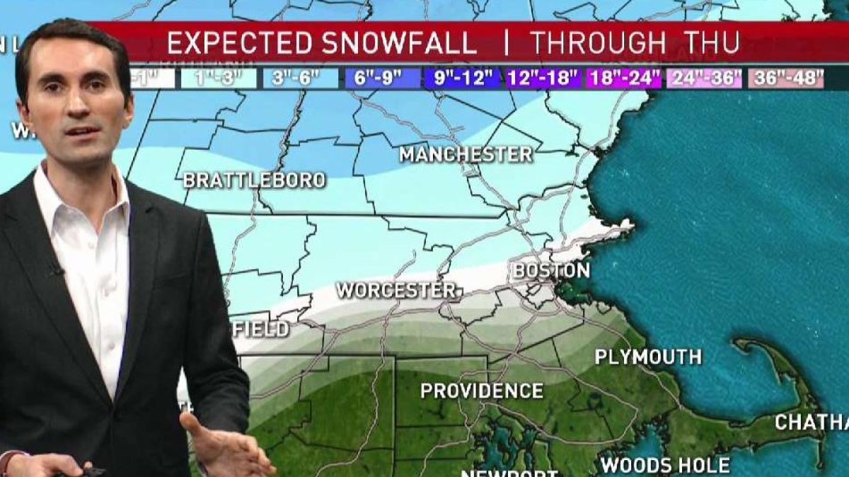
When you combine the snow over the coming days, some of the mountains of northern New England will get 1 to 2 feet of snow.
Much of central New England will get 6 to 12 inches of snow.
Expect 3 to 6 inches from the Berkshires across into southern New Hampshire and near the Maine coast, with 1 to 3 inches for parts of central Massachusetts and other areas just north and west of Boston.
From Boston points south and east, perhaps a dusting to 1 inch before mainly rain falls.
This weekend turns colder, with highs in the 20s and 30s,
with a storm likely just missing on Sunday.
We’ll watch some more rain or snow chances next Monday and Wednesday as our active weather continues.