
-
Thousands still without power in Maine and NH as restoration efforts continue
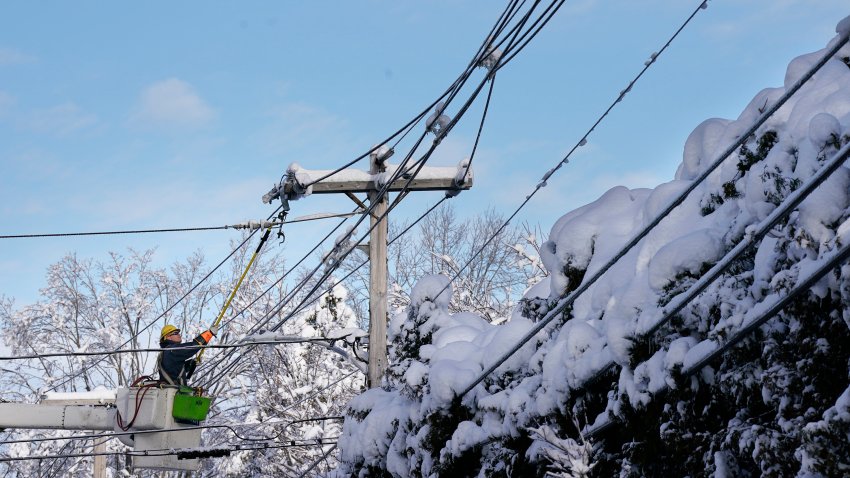
Thousands of customers are still without power in Maine and New Hampshire as restoration efforts continue on Saturday after a nor’easter blasted the region, dropping nearly two feet of heavy, wet snow in some areas. The weather service said it was the biggest April nor’easter to hit the region since 2020. Central Maine Power said 132,279 of its customers still…
-

Cloudy with some leftover showers on Saturday
This isn’t the most stellar weekend, but then again, we don’t expect much from April. Clouds and a few showers will sweep through with our “old” nor’easter passing far off the Seashore. We’ll see brisk, chilly breezes throughout the day (so yes, there’s a bit of a wind chill factor). Highs struggle in the low and mid 40s all...
-
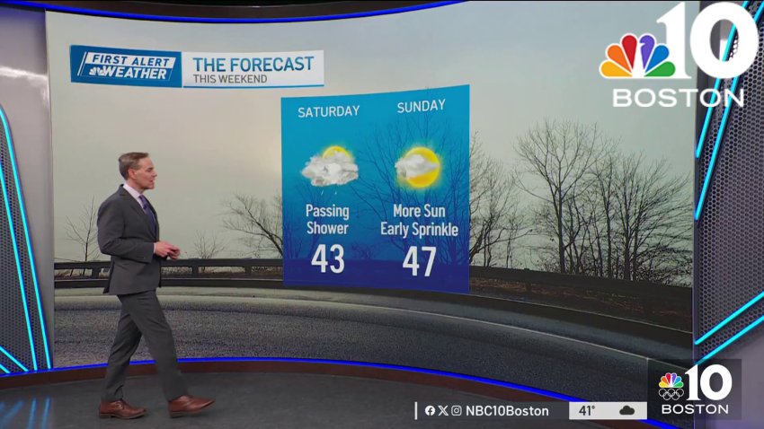
Forecast: Passing shower on Saturday
Overnight Tonight: Chilly air. Brisk Winds: 15-20mph. Lows in the mid 30s.
Saturday: Isolated coastal showers. Highs near 45 degrees.
Sunday: Partly Cloudy. Pockets of sun. Highs near 46 degrees.Follow NBC10 Boston on…
Instagram: instagram.com/nbc10boston
TikTok: tiktok.com/@nbc10boston
Facebook: facebook.com/NBC10Boston
X: twitter.com/NBC10Boston -

Forecast: Chilly, few flurries or sprinkles Friday night
This Evening: Cloudy skies, few flurries or sprinkles. Temps in the 40s....
...
Overnight Tonight: Chilly air. Brisk Winds: 15-20mph. Lows in the mid 30s....
Saturday: Isolated coastal showers. Highs near 45 degrees....
Sunday: Partly Cloudy. Pockets of sun. Highs near 46 degrees....Follow NBC10 Boston on…...
Instagram: instagram.com/nbc10boston...
TikTok: tiktok.com/@nbc10boston...
Facebook: facebook.com/NBC10Boston...
X:... -
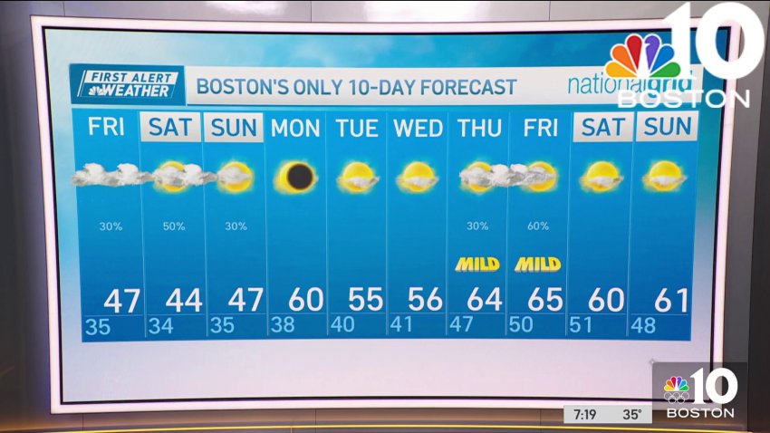
Forecast: Cool, showery spell ahead for Boston, splendid pattern for eclipse Monday
There are chances for rain over the weekend, but the system should clear out in time to see the eclipse....
...Friday evening: Cloudy skies, few flurries or sprinkles. Temps in the 40s. Overnight Friday night: Chilly air. Brisk Winds: 15-20mph. Lows in the mid 30s. Saturday: Isolated coastal showers. Highs near 45 degrees. Sunday: Partly Cloudy. Pockets of sun. Highs near 46...
-
Few days away from the total solar eclipse, forecast in our favor
Friday: Morning flurries. Cloudy skies. Highs in the mid 40s.
Overnight Tonight: Chilly air. Brisk Winds: 15-20mph. Lows in the mid 30s.
Saturday: Isolated coastal showers. Highs near 45 degrees.
Sunday: Partly Cloudy. Pockets of sun. Highs near 46 degrees. -
Nor'easter moves on, but rain and snow showers linger in New England
Our nor’easter continues to slowly move away from southern New England…kind of. This storm continues to weaken and loop around in the Gulf of Maine over the next couple of days, keeping us unsettled and raw. Snow showers linger but they will be rather light and scattered through Friday. The snow from Thursday really helped out ski areas! Some...
-
Snowfall totals map: This week's nor'easter dropped 2 feet of snow on parts of New England
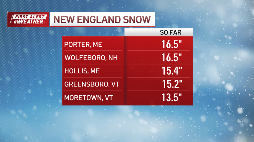
This week’s long-duration nor’easter dropped as much as two feet of snow on some parts of northern New England. The town of Moretown in central Vermont, had seen 24 inches of snow as of 8 a.m. Friday., and a foot or more of snowfall was common across parts of Vermont, Maine and New Hampshire. Here’s a look at some...
-
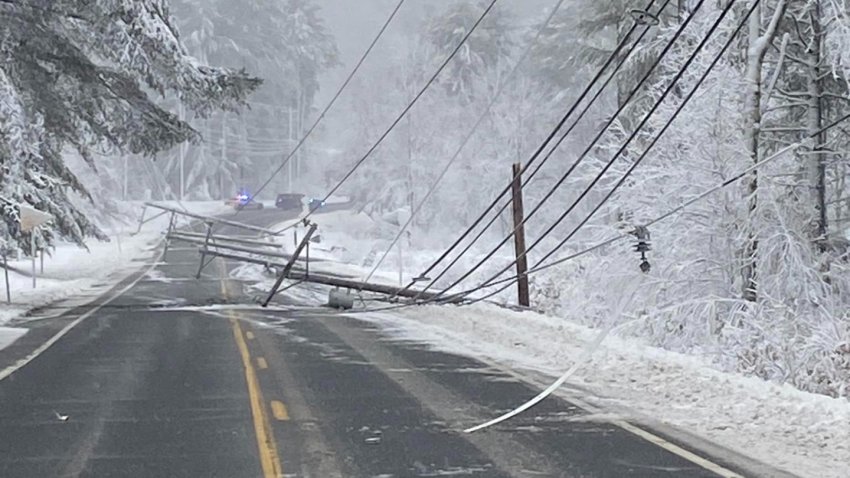
Over 300,000 still without power in Maine and NH amid multi-day restoration effort
Over 300,000 customers are still without power in Maine and New Hampshire after a nor’easter blasted the region, dropping nearly two feet of heavy, wet snow in some areas. “This was pretty much a classic nor’easter,” said Stephen Baron, a meteorologist for the weather service in Gray, Maine. “This is definitely a high-end storm for April. It’s not crazy...
-
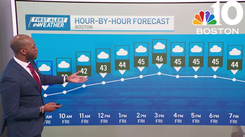
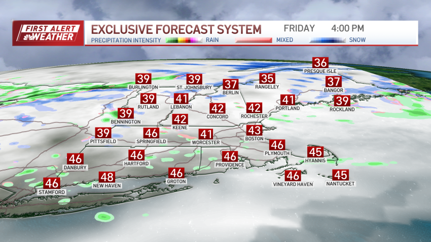
Cloudy in Boston Friday, with highs in the mid-40s
Friday: Morning flurries. Cloudy skies. Highs in the mid 40s.
Overnight Tonight: Chilly air. Brisk Winds: 15-20mph. Lows in the mid 30s.
Saturday: Isolated coastal showers. Highs near 45 degrees.
Sunday: Partly Cloudy. Pockets of sun. Highs near 46 degrees. -
Weather forecast: Lingering sprinkles and flurries
Thursday night: Cloudy with a lingering sprinkle or flurry. Lows around 32 in the suburbs, mid 30s downtown. Icy spots inland. Friday: Chance of a passing shower. Highs in the mid to upper 40s. Saturday: Mostly cloudy. Chance of a shower, mainly at the coast. Highs in the mid 40s.
-
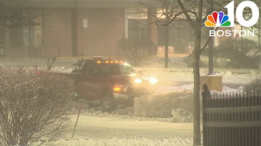
Nor'easter brings snow, coastal flooding and power outages
An April storm brought wintry weather to New England Wednesday and Thursday.
-
After the storm comes cold | Boston's latest forecast
The storm that brought rain, sleet and snow is moving out, leaving cold temperatures in its wake....
...Overnight Thursday night: Cloudy with a lingering sprinkle or flurry. Lows around 32 in the suburbs, mid 30s downtown. Icy spots inland....
Friday: Chance of a passing shower. Highs in the mid to upper 40s....
Saturday: Mostly cloudy. Chance of a shower, mainly at the coast.... -
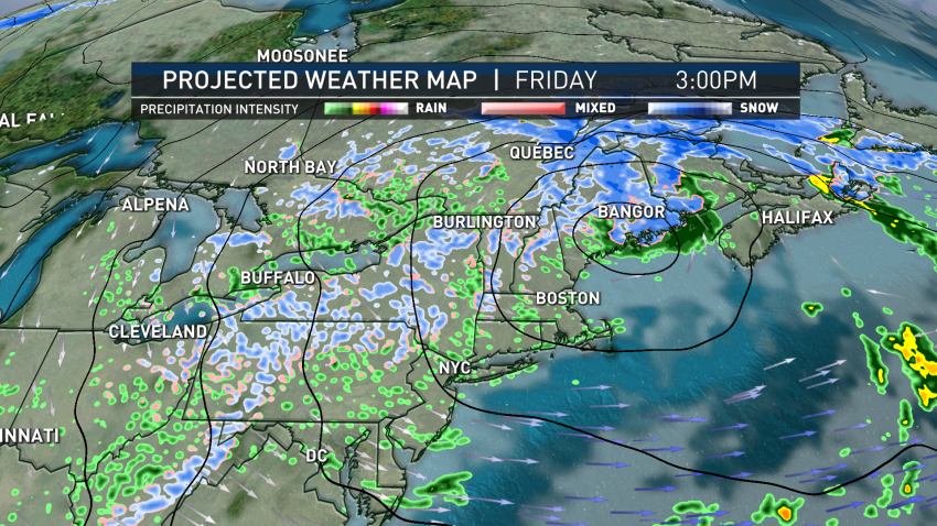
Not done yet: Nor'easter expected to linger over New England through the weekend
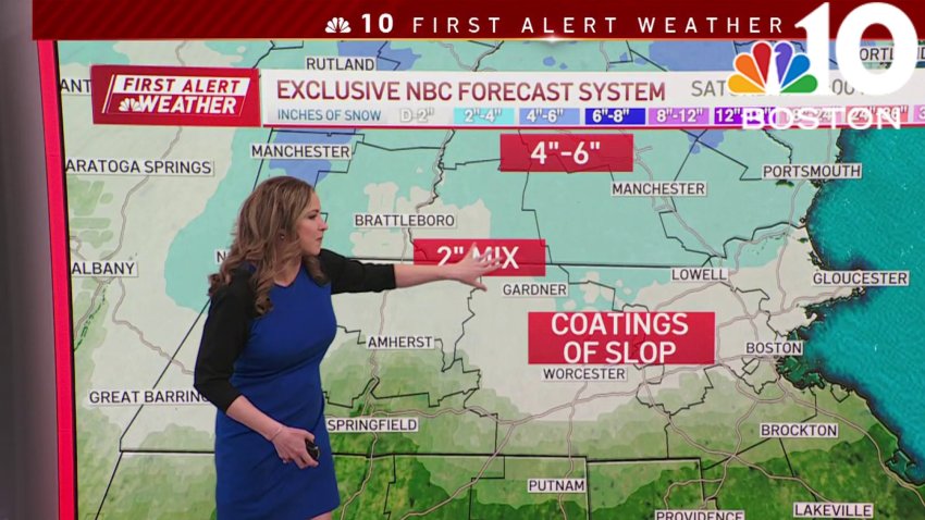
This nor’easter has certainly packed a punch, and it’s not done quite yet. The storm itself will meander close by over the coming days, pinwheeling moisture back over us from time to time. The bulk of accumulating snow is complete in southern New England, though additional sloppy coatings to as much as an inch or two along the Massachusetts/New...
-
Nor'easter continues to linger in Boston Thursday, with wintry mix
Thursday: Cloudy morning. Rain tapers this afternoon. Few flurries. Highs in the low 40s.
Overnight Thursday night: Chilly air. Brisk Winds: 15-20mph. Lows in the mid 30s.
Friday: Few isolated pockets of sprinkles. Highs in the upper 40s.
Saturday: Partly Cloudy. Isolated coastal showers. Highs near 45 degrees. -
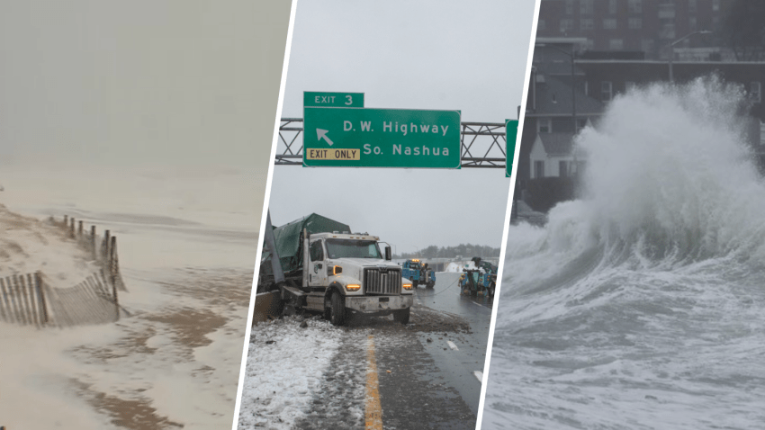
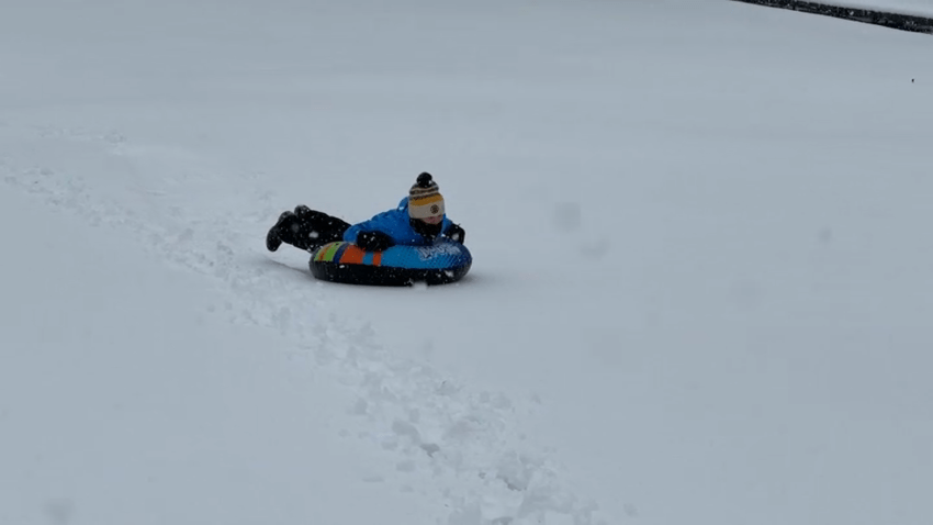
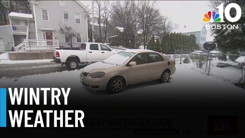
PHOTOS: Winter storm slams Mass., NH — in spring
The powerful nor’easter hitting Massachusetts and much of New England on Thursday churned up sea foam, sent trucks skidding into highway signs and caused power outages. See some of the most interesting sights from around the region during Thursday’s storm here:
-
Snowfall totals map: Some areas of New England received over a foot overnight
Some areas of northern New England have already received over a foot of snow as a result of the nor’easter that swept across the region overnight. The town of Greensboro, Vermont, had seen 15.2 inches of snow as of 1 p.m. Thursday, and 10 inches or more of snowfall was common across northern Maine, New Hampshire and Vermont. Here’s a…
-
Tracking nor'easter impact across Mass.
From the icy roads to the coastal concerns, NBC10 Boston is tracking the nor’easter impact across Massachusetts.
-
Nor'easter batters Mass., NH with heavy rain, sleet, snow and wind
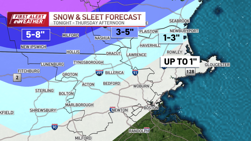
As the nor’easter continues to rage Thursday morning, we’re still seeing plenty of sleet as the precipitation du jour. For the record, sleet is more slippery than snow since flakes readily melt (or more easily manipulated by road treatment) while sleet maintains its integrity longer as solid ice. And since temperatures are near freezing, it’s extra slippery (any frozen...
-

Forecast: Wintry weather continues overnight for many
Wednesday night: Downpours with snow west. Gusty to damaging winds: 40-50mph. Lows in the upper 30s. Thursday: Windy. Gusts near 40mph. Rain and sleet taper mid-morning. Highs in the 40s. Friday: Cloudy and overcast. Isolated and scattered rain. Highs near 45 degrees.
Trending
