A cool-down is in store for today. Chilly breezes blowing from the east and northeast will make sure highs only manage to reach the low and mid-70s near the coast, and upper 70s far to the west of Worcester.
The sun still dominates the forecast, however. We’ll be challenged by a few more clouds in the forecast tomorrow, but at least the temperatures will start to warm up.
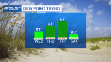
South winds will blow and the humidity will creep back slowly on Thursday. We’ll stay dry, but we’ll likely start with an mostly cloudy sky. This is all priming us for a warmer forecast on Friday.
Get Boston local news, weather forecasts, lifestyle and entertainment stories to your inbox. Sign up for NBC Boston’s newsletters.
That particular day will be filled with heat and humidity. Overnight storms on Thursday will drag their feet into Friday morning, then we’ll have clearing as the heat sets in. The big question revolves around whether or not storms will form later in the day.
Right now, the threat doesn’t seem widespread, but it wouldn’t take much to get a storm going. On that train of thought, the storms seem few and far between, but may pack a punch. Stay “weather aware” later in the afternoon and early part of the evening on Friday.
The weekend looks cooler, but still mostly dry. A brief shower is possible Saturday afternoon. Father’s Day looks cooler and pleasant. Like much of the weather so far this month: not half-bad.
Get updates on what's happening in Boston to your inbox. Sign up for our News Headlines newsletter.