It’s a drab, cool, damp day. The kind of day you’d occasionally expect in mid-May with cool winds off the water and a few showers moving through. And the kind of day you’ll be wishing for this weekend, too.
After this system passes, we’ll go through a transition day tomorrow before we see the fiery hot weather charge in for the weekend.
Daily high temp records are not only in jeopardy, but also ALL-TIME May records may be within reach (Boston 97, Worcester 94). The upper atmosphere is piping hot, and with full sun it’s likely to soar in the afternoon.

Get Boston local news, weather forecasts, lifestyle and entertainment stories to your inbox. Sign up for NBC Boston’s newsletters.
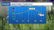
Dewpoints will also climb through the day. We’re not seeing this as a super-humid weekend, but enough humidity is in the air to make it feel very uncomfortable and to raise the heat index (what it feels like with the heat and humidity) to the upper 90s. Take it slow, drink plenty of water, seek shade and lather on the sunscreen.
Get updates on what's happening in Boston to your inbox. Sign up for our News Headlines newsletter.
Relief will arrive by late Sunday night. A cool front slicing through could trigger an isolated (very few in coverage) storm into the late afternoon or evening. Most importantly, the cooler, less humid air will be transported in as well. Monday breaks the hot spell (not a heat wave since we don’t get three straight days of 90+) as highs settle back to the 70s.
Early look on Memorial Day weekend: more heat is possible toward the end of the holiday weekend. Now go forth and “enjoy” the cool, rainy day.