A high pressure system has controlled much of the weather Wednesday, but as a trough enters Vermont and New Hampshire, showers have now started to roll into the north, producing light to moderate activity, short in duration.
While cloud coverage will continue overnight, it prevents a more efficient way of cooling off the ground due to long-wave radiation, so our lows won’t be dropping too much -- they’ll stay in the 50s.
Some fog may develop Thursday morning and allow for visibilities to reduce again into less than a mile for some.
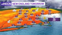
But as this high pressure system remains, we’ll continue to track above-average temperatures tomorrow.
Get Boston local news, weather forecasts, lifestyle and entertainment stories to your inbox. Sign up for NBC Boston’s newsletters.

A back-door cold front will push in Friday, bringing in a northeast breeze and allowing for temperatures to drop into the low 70s. A few spots in the north will even get into the upper 60s.
But a strong frontal boundary that has produced snow over Wyoming, Utah and Montana will head into Canada and affect the Midwest, then traveling to New England this weekend.
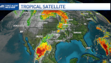
Looking at the big picture, we can see the snow storm in the northern states and a tropical storm, Pamela, in Mexico. Moisture is feeding the thunderstorm activity in Texas and the Great Plains. This is the same frontal boundary that will provide showers for us Saturday.

This Saturday, we’ll expect to see breezy conditions and possible thunder. Sunday will remain breezy, and expect to wind down late afternoon and into Monday.
Local
In-depth news coverage of the Greater Boston Area.
By then, we’ll see a mostly sunny afternoon, with highs in the low 60s -- another dip into the fall feeling and crisp air.
The first half of next week looks fantastic, with minimum rain chances, highs in the 60s and mostly sunny skies. Unsettled weather may return by next Thursday and bring another round of precipitation.


