
Another numbing start across the Commonwealth. We’re scraping the bottom of the temperature barrel as some communities start in the single digits. High pressure was directly overhead, and allowed the temperatures to plummet just after the sunset last night.
Speaking of sun, there isn’t a ton in the forecast in the coming days. We’ll fight the good fight to keep the dense overcast away today, but even then, the sun will struggle. None tomorrow and none expected through Friday; bleak week in that sense.
WATCH ANYTIME FOR FREE
Stream NBC10 Boston news for free, 24/7, wherever you are. |
Ironically, the clouds are a result of a milder trend that will take hold in the coming days (bring back the arctic air?). Although we may just barely bust freezing in many spots today, it certainly won’t feel like it without El Sol.
Milder breezes may help tomorrow. Highs make the mid-40s….then peak Thursday in the upper 40s. We’ll do some melting, but this isn’t a meltdown. Cold air lurks around the corner, and should swoop down on Friday.
Get updates on what's happening in Boston to your inbox. Sign up for our News Headlines newsletter.
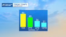
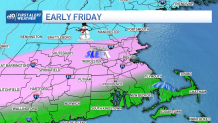
The weather issue of the week is that there’s a front coming in Friday. Ahead of it, we’ll be warm enough to start as rain, but as the colder air seeps in during the morning and afternoon, we should switch to sleet (ice) and eventually some snow.
Accumulations look light, but the freeze up is the big issue. We’ll fall from the 40s (or even 50) before sunup to the 30s as the day wears on. It’s enough cold and mix to make the Friday evening commute a little tricky, so keep that in the back of your mind as the week progresses.
Enjoy the week!