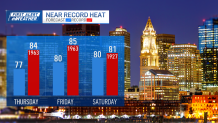
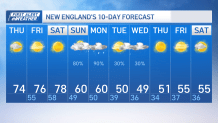
Today: Variable clouds, sprinkle north, mild. Highs in the 70s. Overnight Tonight: Mostly cloudy. Lows in the 50s. Friday: Clouds give way to sun. Highs 75-80. Saturday: Record challenging warmth, fair. Highs around 80.
We can thank a ridge of high pressure for these mild mornings and warm afternoons as our highs keep climbing above average through the end of the week accompanied by mostly sunny skies.
Our afternoon will be decorated by sunshine and temperatures rising as high as the upper 70s in eastern Mass. Our temperatures overnight should also range in the upper 50s to 60 which is also above average.
WATCH ANYTIME FOR FREE
Stream NBC10 Boston news for free, 24/7, wherever you are. |

In Boston, our normal highs by this time of year is around 59 and our average low is around 45. Our lows tonight will only dip to 60 in Boston along with mostly cloudy skies again, which won’t give much way for radiational cooling.
Get updates on what's happening in Boston to your inbox. Sign up for our News Headlines newsletter.
Friday welcomes even warmer temperatures with highs climbing as high as 80 in Boston and upper 70s all across southern New England. Manchester, NH and Westfield, MA may cross the benchmark and set new temperature records.

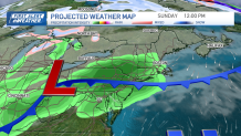
Sunny skies should cover much of New England again tomorrow with dry weather through Saturday with the exception of a few communities out in the north country who may see a round of spotty showers Saturday afternoon with the passage of our cold front.
Sunday, however, is the jackpot for the rain and the cooler weather as our highs dip to the upper 50s and low 60s all the way through Tuesday and Wednesday.

Halloween may offer highs around 50 with lows in the 30s. Wednesday may actually also hover around the upper 40s much of the day.
A few showers may also creep back in. With these colder temperatures, parts of the far north country in VT & NH but especially Maine may see from an inch to 3 inches of snow through Monday. Another round can be expected Wednesday.


