After a fabulous weekend with warm and dry conditions, today we’ll start to make the transition to hotter and more humid air.
We’ll see a good deal of sunshine today with warm temperatures across much of the region. The only exception will be northern Maine, where we’ll see more in the way of clouds as well as a stray morning and afternoon shower/sprinkle as a system passes well north.
The day will start off with dewpoints in a tolerable range. But as we head through the afternoon, southerly winds will increase, ushering in a more humid airmass and making it feel a bit more sticky this evening and especially overnight.
Highs will reach the mid 80s with slightly cooler temps along the south coast and far northern Maine. Lows tonight will be mostly in the 60s north to around 70 south with a few passing clouds and a gusty southwest wind.
Get Boston local news, weather forecasts, lifestyle and entertainment stories to your inbox. Sign up for NBC Boston’s newsletters.
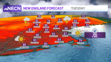
Turn those AC’s on because the heat and humidity are back on Tuesday with highs reaching the upper 80s to low 90s and dewpoints breaking into the 60s!
A few showers and thunderstorms will pass through central and northern New England during the early morning, some may sneak into southern areas as well, but most of these will weaken and dry up by the mid to late morning hours. It’ll be hot, humid, and breezy during the afternoon with a few isolated showers and storms popping up, but most areas will remain dry.
A few more showers and storms will develop during the late afternoon and evening hours as a cold front passes through the region. Some of the storms may be strong to severe, with the main threat being gusty winds and hail. There's still some uncertainty on the timing of the front, which will be crucial in determining the intensity of the intensity of the showers and storms.
Get updates on what's happening in Boston to your inbox. Sign up for our News Headlines newsletter.
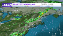
Regardless, we put the First Alert Stamp on Tuesday in our Exclusive 10-Day Forecast due to the potential of severe storms. The severe threat will end early Tuesday night, but a few showers and storms may linger into the late night hours.
The heat and humidity remains with us through Wednesday with the slight chance for afternoon showers and storms. Drier and slightly cooler air arrives Thursday and Friday, but we’ll still keep the threat for a afternoon showers in the forecast since the air will still be a bit unstable.