After some towns peaked at over 5 inches of rain (Rockland, Lakeville, I’m looking at you) it’s finally time to dry out.
Sun dominates the next two days, and today the sun’s energy will go into evaporating the rain and overall wetness from the soil. For that reason, our high temps will fall short of 90 degrees in many spots. But don’t worry, there’s always tomorrow.
Many locations will hover near that mark as the breezes blow from the south/southwest. Both are looking like stellar beach days, but thanks to the breeze we’ll be bit cooler than 90 on the Cape and Islands and from Marblehead to Gloucester.

Get Boston local news, weather forecasts, lifestyle and entertainment stories to your inbox. Sign up for NBC Boston’s newsletters.
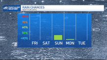
Sunday’s weather has us in a squeeze play between an advancing front from the north and a super-weak storm drifting off Nantucket. The question is, will we stay dry all day long? It’s a tall order, but I think our chances are good.
The system offshore is mighty weak and could only muster a brief morning shower for the Cape and Islands. Then the front to the north runs out of gas near the border, so our best chance for a storm would likely be across the Merrimack Valley and Southern NH. Either way you slice it, with clouds around, our temps sink back to the low and mid-80s.
Sea breezes strengthen on Monday with the passage of the aforementioned front. With the clouds and sun blending, we’ll likely only manage the 70s along the coast. Still near 80 elsewhere. And I know you’re thinking, “We’re not going to warm up next week.”
Weather Stories


Ha! Not so fast. Our heat wave may be a little delayed…but we won’t be denied. Starts warming up on Tuesday and keeps rolling through early next weekend. Humidity will be climbing in kind, so get ready to bury your toes in the sand.
And if you’re on vacation, well played….closet meteorologist.