


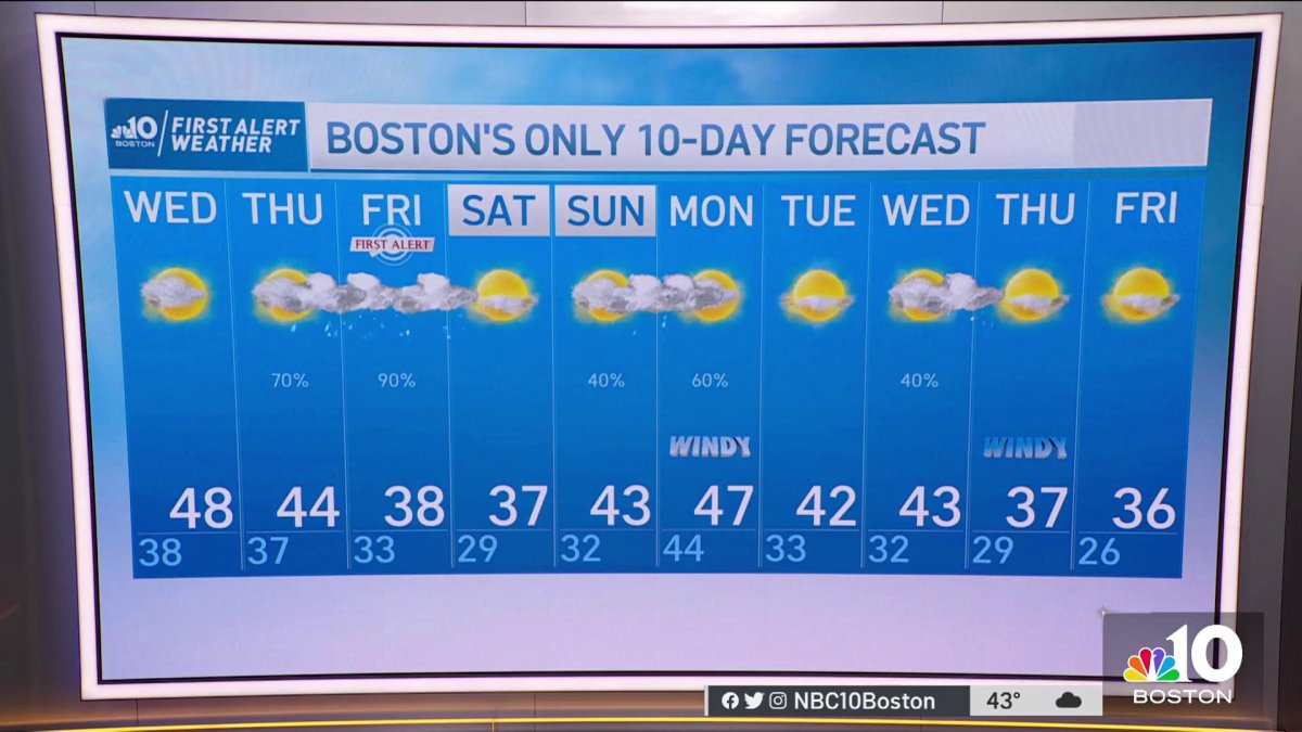
Tuesday evening: Clouds and a few showers. Temperatures in the low 40s. Tuesday night: Showers dwindle to sprinkles. Lows in the 30s. Wednesday: Mostly cloudy, occasional sprinkles and light showers, late day clearing. Highs in the 40s.
Snow shouldn’t be a surprise in January, but with winter’s slow arrival today’s snow was quite the turn of events. To make matters even more abnormal, the system that brought us snow is an area of low pressure roughly 500 miles east and southeast of New England. The storm at one point produced thunderstorms over the ocean and even had an eye feature to it, resembling a tropical storm or hurricane. While not a well-defined hurricane, nor tropical storm, the National Hurricane Center did have it labeled as an invest…which is also a rarity for this time of year.
Higher end snow totals ranged from between 4 and 5”. Most of the action was confined to the coast, where Duxbury measured 4.5” of snow. Not far behind, areas of Dorchester picked up 3.9” of snow for this particular event.
Sunday was the first day of the event, as 1.6” of snow fell in Boston. This marked the city’s first 1” snowfall day of the season, the 6th latest on record. Most of the snow added up on elevated surfaces and grassy areas, while roadways were spared due to warmer temperatures and road crews depositing pre-treatment.
As that system continues to depart, dry skies return in its wake. The snow will be a thing of the past with temperatures climbing into the 40s tomorrow, to near 50° mark by Wednesday.
Get Boston local news, weather forecasts, lifestyle and entertainment stories to your inbox. Sign up for NBC Boston’s newsletters.
There’s a weak disturbance that moves through briefly on Tuesday afternoon. It will likely keep clouds across the south coast, with a few spotty (rain) showers between 6p and 9p Tuesday evening. Wednesday is the warmer and drier day. That dry spell is temporary, as clouds build in before snow and rain showers on Thursday evening and Friday. Right now, it seems as the system starts with a mix of rain and showers in the Merrimack Valley, Northern Worcester County and across Essex County, as rain then takes hold with a warm front nudging in. Rainfall amounts will likely be near half an inch to an inch. There will be a window of opportunity for snow as colder air pours in from the west to east. This system, unlike its predecessor, will move through much quicker, and will be warmer, hence the higher rain (versus snow) totals.

