
-
FORECAST: Weekend concludes with wintry mix
Overnight Tonight: Cloudy, some patchy fog, risk for shower late. Lows low 30s.
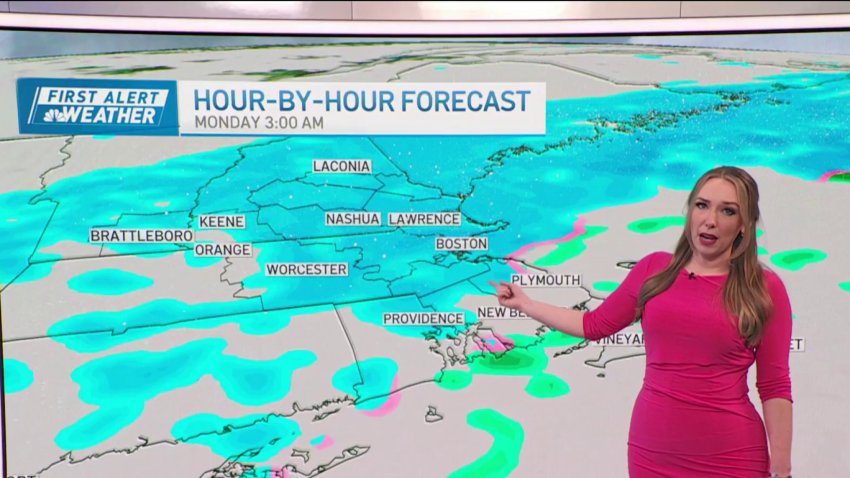
Sunday: Snow develops inland, rain and mix coast, changes to snow late in the day into the overnight, gusty northeast wind. Highs in the 30s. -
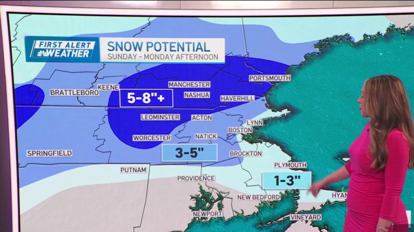
FORECAST: Slush and snow returns Sunday
Overnight Tonight: Cloudy, some patchy fog, risk for shower late. Lows low 30s.
Sunday: Snow develops inland, rain and mix coast, changes to snow late in the day into the overnight, gusty northeast wind. Highs in the 30s. -
Winter weather may finally arrive this season
Welcome to 2024! As if on cue, winter decides to enter the chat this week with a couple of snow threats – not the least of which is a potential nor’easter. First up, the QUIET of New Year’s Day (our weather gift to you if you’re nursing a throbbing headache) with chilly temps and limited sunshine. Tomorrow looks like...
-
FORECAST: Clear, mild first day of the year
Today (Monday): Clouds & sun. Highs in the 30s.
Overnight Tonight: Mostly clear. Lows in the 20s.
Tuesday: Sunny. Highs around 40.
Wednesday: Some AM clouds to a mostly sunny sky. Highs around 40. -
FORECAST: Temps remain mild for Christmas
Sunday: Mostly cloudy, a stray sprinkle. Highs in the 40s.
Christmas Day: AM clouds, pt. cloudy PM. Highs near 50.
Tuesday: Mostly cloudy. High in the low 50s. -
FORECAST: Thunderstorms to close out the weekend
Overnight (Saturday): Mostly cloudy, some fog. Lows upper 30s to low 40s.
Sunday: Overcast, afternoon showers, increasing wind, mild. Highs around 60.
Sunday Night: Rain, embedded thunder, damaging wind & flooding possible. Lows in the 50s -
FORECAST: Freezing overnight temps
Today: Cold start, morning sun, some afternoon clouds. Highs 35-40, wind chill low 30s.
Tonight (Saturday): Few clouds, cold. Lows 25-30.
Sunday: Increasing clouds, not as cold. Highs low to mid 40s.
Sunday night: Rain develops overnight, breezy. Lows around 40. -
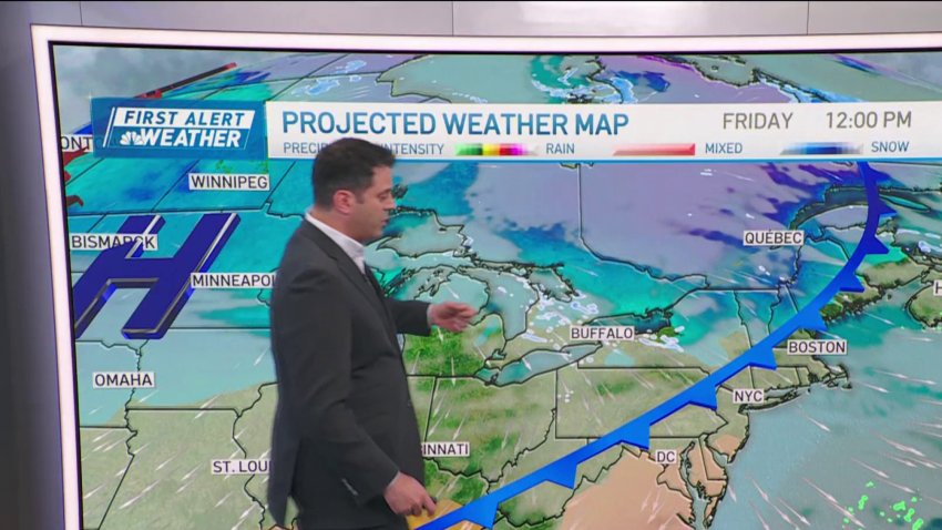
FORECAST: Cold front moves in
Overnight Tonight: Wintry cold & clear. Lows around 20, 10s north – wind chill teens.
Saturday: Frigid morning. Sun & increasing clouds. Highs 35-40.
Sunday: Not as cold, sun to clouds. Night rain. Highs in the 40s.
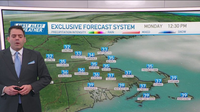
Monday: Periods of morning Rain. Mild: Highs near 50. -
FORECAST: Cold and clear Thanksgiving weekend
Overnight Tonight: Wintry cold & clear. Lows around 20, 10s north – wind chill teens.
Saturday: Frigid morning. Sun & increasing clouds. Highs 35-40.
Sunday: Not as cold, sun to clouds. Night rain. Highs in the 40s.
Monday: Periods of morning Rain. Mild: Highs near 50. -
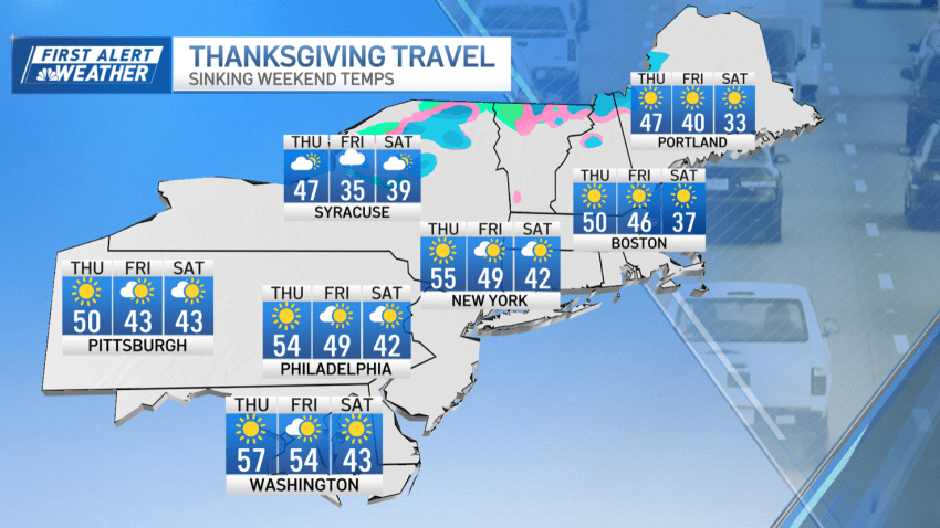
Beautiful, breezy Thanksgiving holiday weekend
We’re off to a good start for the holiday weekend. Yesterday’s highs in the 50s will try and hang on along the coast and down throughout Southeastern Massachusetts, but the higher elevations around Greater Worcester and most of the Merrimack Valley will remain in the cooler mid-40s. Winds will be brisk, but the gusts ease by afternoon as you...
-
FORECAST: Beautiful, breezy Thanksgiving Day
Today (Thanksgiving Day): Mostly sunny, breezy AM, comfortable air. Highs around 50.
Overnight Tonight: Partly cloudy. Lows in the 30s, 20s north.
Friday: Fair, seasonable air. Highs in the 40s.
Saturday: Sunny, but very chilly. Highs in the 30s. -
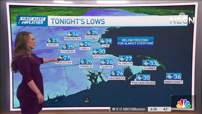
Weather forecast: Cold night
Saturday night: Temperatures in the low 30s in Boston, upper 20s in the suburbs. Sunday: Frosty morning. Highs in the lower to mid 40s, sunny skies. Monday: Frigid start in the 20s inland, around 30 in Boston, highs in the upper 40s, sunny afternoon.
-
Cold, clear days, freezing temperatures by night
Our holiday weekend is keeping beautiful sunny skies along dry but cool conditions. A high pressure dominating the region should keep temperatures below average through early next week. Today’s brisk northwest winds keeps the “feels-like” temperatures in the lower to mid 40s. Away from Cape Cod, we keep mostly clear skies and decreasing winds this evening into tonight which...
-
FORECAST: Nightly temps hit freezing
Today: Plenty of sun. Highs in the upper 40s. Winds: WNW 10-15mph, gusting 20mph.
Overnight: Temperatures in the low 30s Boston, upper 20s suburbs.
Sunday: Frosty morning. Highs in the lower to mid-40s, sunny skies.
Monday: Frigid start in the 20s inland, around 30 in Boston, highs in the upper 40s, sunny afternoon. -
Forecast: Temps rise as week continues
Overnight: Lows in the lower to mid-40s, mostly cloudy. Monday: Brighter, highs in the upper 50s, breezy, gusting up to 20 mph. Tuesday: Chilly morning, possible patchy frost inland, mostly sunny PM, highs around 60.
-
Forecast: Cool, clear start to the week
Tonight: Mostly cloudy early then becoming partly cloudy. Low near 50. Sunday: Partly cloudy and breezy. High around 60. Monday: Partly cloudy, a stray shower or two possible. High around 60.
-
Temperatures to reach 40s overnight
Tonight: Partly to mostly cloudy. An isolated sprinkle. Lows in the 40s. Monday: Sun and clouds. Breezy. Gusts to 20 mph. Highs in the middle 60s.
-
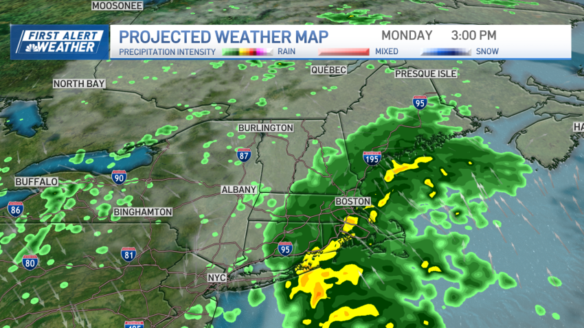
Forecast: First Alert in place for Monday
Monday: Mostly cloudy with showers. Highs 65-70.
-
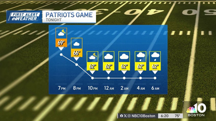
Forecast: Beautiful night for football
Sunday: Sunny and delightful. Highs 75-80.
Monday: Mostly cloudy with showers. Highs 65-70. -
Perfect weather for Sunday Night Football before thunderstorms return Monday
High pressure will provide us with a beautiful afternoon with plenty of sunshine to go around. Highs Sunday reach the mid to upper 70s along with a wind out of the northwest 7-15 mph. Seas will still be a bit rough in the wake of Lee, so watch for rip currents if you’re headed to the beaches. No weather issues...
Trending
