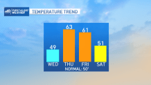
It's another very cold start. It's worth noting that this cold snap has been both intense and lengthy. The last two days have seen temperatures between 13 and 15 degrees below normal.
While we still may be slightly below normal today, it's nothing to that extent. In fact, we'll chalk this one up as a day where we turn the corner and mount a comeback in the temperature department.
WATCH ANYTIME FOR FREE
Stream NBC10 Boston news for free, 24/7, wherever you are. |
Highs race to the upper 40s before the clouds take hold. Even at night, we won't cool much thanks to the southwest breeze.
Sign up for our Breaking newsletter to get the most urgent news stories in your inbox.
Get updates on what's happening in Boston to your inbox. Sign up for our News Headlines newsletter.
We'll continue to climb tomorrow as the clouds continue to cram our skies. There may be a sprinkle, but there also may be some sunny breaks. This firms up our idea that low and mid 60s are well within our reach.
Meantime, storms are aiming for the Deep South. Sadly, the entire state of Mississippi is under the gun for a tornado outbreak later today and tonight. That same storm pays us a visit late Thursday night with a chance at some storms and downpours here (non-severe).
We'll hang on to some of the warmth through Friday before the cooler air arrives for the weekend. We're likely to keep away the showers Saturday, but Sunday some could sneak in late. Updates in the coming days.