
I’m going to cut to the chase. This kind of pattern is really hard to shake. For one, the fact that we’ve made it to summer means the overall pattern across the Northern Hemisphere has slowed. Moreover, in the warm season, there are feedback processes that make it hard to turn things around. Once you’re wet, it tends to stay wet (water is cycled through the atmosphere) and once you’re dry, you tend to stay dry (see last year’s drought). Lastly, the pattern from Japan to Alaska is about to be reinforced by a recurving tropical cyclone. This will have the effect of refreshing the same type of setup (favoring cooler than normal weather and some rain) across the Eastern Seaboard.
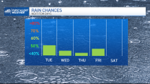
All is not hopeless, however. We still will see some sun in the coming days. We will also be vulnerable to afternoon showers and storms that flare up with such an unstable setup. Keep an eye to the sky Tuesday for any heavy bursts of rain or localized gusty winds. We’ll repeat the process each afternoon through Friday, with fewer showers each day, and a very minimal threat for storms.
Get Boston local news, weather forecasts, lifestyle and entertainment stories to your inbox. Sign up for NBC Boston’s newsletters.
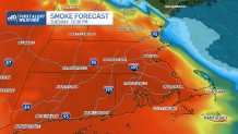
Wildfires raging across Quebec and Ontario still aren’t contained. Smoke arrived in the area overnight, and will be locally dense in spots Tuesday. Air quality will be poor and visibility will be limited. Also, you may be able to smell the smoke since it will be near ground level (unlike a couple of weeks ago when it was thousands of feet aloft). If you suffer from respiratory ailments, limit your time outdoors Tuesday.
