
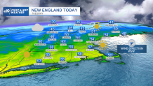
Temperatures are going back up on Thursday, as highs climb to the 50s all across New England. The warmest spots, inland, might hit 60 degrees. Normal numbers for Boston should sit around 47 degrees, so we’re about 10 degrees above that on Thursday.
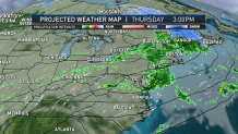
Showers, however, will keep scrolling through in the afternoon and evening. Fortunately for all the Friday lovers, (who isn’t?), the work week ends with drier conditions, variable clouds and temperatures in the lower 50s.
The weekend offers an improved day, and that’s Sunday! But let’s talk about the details: Saturday will increase clouds by the early morning, and rain and snow showers begin to creep up out of the west and south west.
Get Boston local news, weather forecasts, lifestyle and entertainment stories to your inbox. Sign up for NBC Boston’s newsletters.
It’s possible that the Berkshires and Litchfield Hills get to see some snow showers before temperatures rise slightly warmer and switch to rain. The snow line will push north throughout the day, producing snow in the Green and White mountains, and sleet and rain in the valleys and lower elevations.
Sunday morning keeps the snow north while the rain will begin to push out allowing for increasing sun and milder temperatures south of the Merrimack Valley. Snowfall totals now have begun to lower compared to Wednesday's estimate. Our highest totals in Vermont and much of New Hampshire may end up with 2 to 4 inches while Maine may reach 6 to 8 inches.
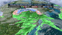
Temperatures Saturday vs Sunday will also vary, with the passage of Saturday’s cold front, temperatures will stay in the lower 40s for the first half of the weekend with a milder Sunday reaching the lower 50s. After that, temperatures remain in the lower 50s Monday with 40s for the rest of the week. Our next system arrives mid-week bringing rain & snow.
