
The storm is nearly upon us and the picture is becoming clearer on the timing and impacts through Sunday. Winter storm warnings have been issued for parts of Massachusetts and New Hampshire.
Here's what we know:
When does the snow start in Boston?
First wave of snow and mix will hit just after 8 tonight.This band will account for the vast majority of our accumulation for the storm as it carries into the predawn hours Sunday. (Except on the immediate coast, where we get most of our accumulation tomorrow afternoon and evening as the cold rushes in.)
Get Boston local news, weather forecasts, lifestyle and entertainment stories to your inbox. Sign up for NBC Boston’s newsletters.
How much snow will Massachusetts get?
Inside I-495, the accumulation will wet, heavy and generally less than 6” (closer to the coast even less). The Worcester Hills, southern New Hampshire, and many spots in western Massachusetts will see a fluffier snow, but still sticky enough to compact into a snowball. Siblings beware.


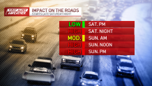
Any precipitation scales way back through the early part of Sunday. This is a good cleanup (and travel) time, as the temps will hold in the low and mid-30s. If you leave it for the afternoon, it will freeze solid (on untreated surfaces). Colder air will come rushing out of southern NH and outer Route 2 to drop our temperatures to the 20s within a few hours starting after noon.
Live radar of the Massachusetts snowstorm
This temperature drop – also known as a flash freeze - will be accompanied by a burst of snow and wind that will charge all the way to Cape Cod in the late afternoon and evening. This is when the coast finally sees an accumulation. Travel will again go downhill at this time.
The rest of the evening will feature increasing winds, cold wind chills in the teens, and random snow showers. Expect clearing later after midnight.

Monday dawns bright and cold with temps in the teens. We’ll warm in the following days into the 40s as we gear up for a large, windy rainstorm on Wednesday. This has us concerned for flooding rain and possible power outages.
Another storm headed our way
Not like I want to pile on, but there’s yet another storm by next weekend that is also looking loaded with precipitation. Trend is a little colder with that one. We’ll be watching.

Make the best of this stormy weekend and be safe! We’re streaming online and wherever you stream your favorite programs.


