
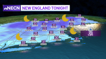
After another brisk day, our wind subsides after sunset. As it does, some of the upslope snow in the mountains will diminish Tuesday night. Our lows drop to the teens and 20s north and 30s south as we have radiational cooling under a clear sky.
Wednesday is our transition day, with strange temperatures. We will be in the 40s during most of the afternoon, with slowly rising temperatures in the evening through overnight. This is thanks to a warm front that lifts northeast through New England. A couple showers will be around Wednesday in the higher terrain and in northern New England there is a wintry mix.
STAY IN THE KNOW
Watch NBC10 Boston news for free, 24/7, wherever you are. |
|
Get Boston local news, weather forecasts, lifestyle and entertainment stories to your inbox. Sign up for NBC Boston’s newsletters. |
Heavy rain along a cold front heads in late Thursday into Thursday night. Prior to that, we warm up tremendously thanks to a south wind flow. Highs reach the 50s north, 60s to 70 south. The rain moves in for nighttime and will cool us off again to the 40s for Friday through the weekend.
329 medal events. 32 sports. Endless drama. Catch all the action at the Paris Olympics. Sign up for our free Olympics Headlines newsletter.
The weekend is dry for most with highs in the 40s both days. Sunday night into the first of next week another low pressure system tracks north of us and will bring in rain with a wintry mix to snow in higher elevations. This storm system may move a bit slower and linger into Tuesday.
Travel weather improves for Wednesday into Thanksgiving in the northeast as we dry off and expect cool temps in the 40s.
