
We're basking in the spring warmth Thursday….but you have to be a good distance from the coast. Once again, Greater Worcester and parts of Southern New Hampshire come away with the gold as highs reach for the 60s.
Meantime, the coast sees the sea breeze engage by mid-morning. Although the onshore winds are light, their impact will be to keep the temps in the low 50s – with a slant toward the 40s by afternoon.
Rain is moving in Thursday night. It will carry into the early morning, encapsulating our wettest spell with this fast-moving system.
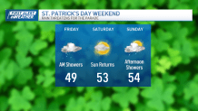
The rest of Friday is spent in the light mist and clouds. This means we’re back to the 40s for much of the day; hardly a stellar way to kick off the holiday weekend.
Get Boston local news, weather forecasts, lifestyle and entertainment stories to your inbox. Sign up for NBC Boston’s newsletters.
What we lack in Friday’s forecast, we make up for in Saturday’s outlook. After a few morning clouds, we’re back to sun and 50s by afternoon. This will be the brightest day of the weekend.
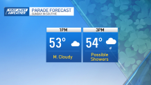
Another fast-moving system is on the way for Sunday, with a few showers scooting in for the afternoon. Nothing in our guidance suggests this will be a heavy rain, so plan on spotty showers for the parade and for much of the remainder of the day.
This system will deepen offshore as it taps into cold air overhead. This will drill down over New England in the form of colder-than-normal temps through midweek.
