What started off as fog and showers has now come to a break of clouds and periods of sunshine. The improvement is not only with fewer clouds but also the increase in temperatures we've seen.
We woke up feeling like it was in the 30s and we now get to see more upper 50s and 60s. It will be a decent evening overall before more changes rush in our way.
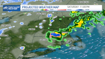
Showers are moving in this weekend, but the great news is that it won't be a complete washout of a weekend.
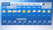
A frontal boundary pushes in Saturday and brings down our temperatures a bit. Highs Saturday will likely remain in the low to mid 50s, and along with that some showers that begin from the west and move into the east in the afternoon.
Get Boston local news, weather forecasts, lifestyle and entertainment stories to your inbox. Sign up for NBC Boston’s newsletters.
If you wake up early, you'll have a chance to have a dry morning jog or walk. However, the showers enter western Massachusetts by early afternoon and reach Boston between 2 and 3 p.m.
More rain will fill in the evening and thunder can't be ruled out either. Because of the drop in temperatures, we'll be watching the chance for snow in the Berkshires that might march into the higher elevations in Worcester County as a wintry mix or light flurries.
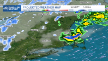
Our Sunday is looking cloudy in the morning, with an afternoon chance of showers, especially from Sunday night into Monday as colder temperatures roll in and bring winter weather back to the forecast.
Local
In-depth news coverage of the Greater Boston Area.


Wind chills on Monday morning will start off in the single digits north and northwest, with low teens in Worcester and upper teens through most of the day. We'll struggle to reach wind chills in the 20s on Monday afternoon due to the strong wind gusts that are expected, so if you have kids who will be waiting for the school bus on Monday morning, make sure they take their winter coats with them.
Tuesday will feature highs in the 40s, but the sunny skies will make a pleasant difference. We'll continue with active gusts of wind, but it will be an improvement after the 20- and 30-degree temperatures from Monday.
In our 10-Day Forecast, we'll see a more active pattern coming along, bringing precipitation chances up and keeping the chance of snow in our mountains as well. Stay tuned to your First Alert team for all of the updates. Make it a great Friday, and enjoy your weekend.