It’s a thin line between snow... and rain.
There are always surprises with these winter-like spring storms. The biggest surprise was early Friday morning when the snow was accumulating in northeastern Connecticut while it was still raining in southern New Hampshire.
Then, even as the sun got higher in the sky, rain changed to snow around Boston and southern New Hampshire about 9 a.m.
Yes, the sun higher in the sky usually makes a difference in spring storms, but apparently not so much this time.
Get Boston local news, weather forecasts, lifestyle and entertainment stories to your inbox. Sign up for NBC Boston’s newsletters.
It was interesting that the cold for the storm moved in from both the east and the west -- a rather unique set up.
It has to do with those two old upper level low pressure systems we’ve been talking about for 10 days.
Local
In-depth news coverage of the Greater Boston Area.


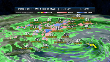
A new low pressure center formed south of Nantucket and deepened to about 29.25 inches on the barometer. That’s a powerful little system.
The more intense bands of precipitation caused the rain to change to snow.
There’s not much change during the day, other than probably an eye-like feature somewhere between Boston and Cape Cod with less intense wind and precipitation, and maybe even a sunny break on Cape Cod, where the temperature may briefly warm past 50 degrees.
Otherwise, heavy snow will continue in the higher elevations and the wintry mix will go back-and-forth at lower elevations.
Temperatures are holding near 40 degrees for the most part, colder and with heavier bands of precipitation at higher elevations.
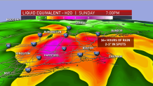
Accumulation ranges from zero to about 20 inches when you move from Cape Cod to Mount Snow in Vermont.
Rainfall and liquid equivalent in snow of this storm will be in excess of 2 inches in many spots, going a long way to alleviate our dry weather of the last couple months.
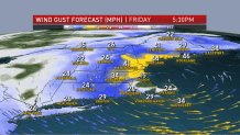
Wind is strongest just to the north of the storm center -- that would be Cape Ann and the New Hampshire seacoast, where a wind advisory is in effect for possible gusts past 50 mph from the northeast.
The storm is going to begin to weaken and only slowly move east and out to sea Friday night and Saturday. We are going to be left with a circulation of instability clouds with a few mixed showers continuing for most of the weekend.
Our best chance of sunshine is near the South Coast and toward the border with New York in western New England. Temperatures for our Saturday are going to be in the 40s, and back into the low 50s in spots on Sunday, when we have breaks of sunshine.
There’s a lot of weather across the nation we have to monitor. One little wave of low pressure could bring us some rain Sunday night and Monday.
There’s going to be a strong storm in the Great Lakes states, with snow near Chicago on Tuesday. We will be on the front side of that, with the wind from the southwest pushing us to near 70 degrees for one day.
That rain/snow mix will come into New England on Wednesday, and we may end up with a situation similar to what’s happening now, only not as intense. But more snow may fall in our mountains next week. Stay tuned to our First Alert 10-Day Forecast for the latest updates.