
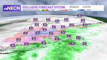
An offshore storm is passing by out in the ocean, but it’s swinging in some precipitation already. As the wind switches from the south Monday afternoon, we switch from the snow or mix to rain near the coast.
The wintry mix continues inland with some freezing rain or sleet, switching to snow and back and forth all day. The colder air remains across northern New England, so we expect mostly light snow all afternoon.
WATCH ANYTIME FOR FREE
Stream NBC10 Boston news for free, 24/7, wherever you are. |
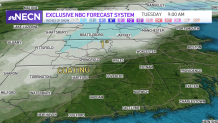
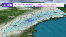
A few inches of accumulation is likely through Tuesday morning across interior Vermont, New Hampshire and Maine. The question is how long does the cold air hang on across southern New England. Roads may stay slick until early evening in Connecticut, Rhode Island or Massachusetts with the wintry mess and colder air at the surface.
Get updates on what's happening in Boston to your inbox. Sign up for our News Headlines newsletter.
Overnight, the wintry mix, snow north and rain at the coast will continue. Then the storm offshore pulls away Tuesday afternoon and takes the precipitation with it. Maine holds on to a little more of this snow until Tuesday afternoon.
Our temperatures will be milder this week, as we see a quiet midweek forecast. Highs will be in the 30s to 40s through at least the first part of the weekend. This means our snow continues to melt, uncovering some new muddy spots. And keep the windshield wiper fluid topped off in the car -- road spray continues to be a problem out there.
Local
In-depth news coverage of the Greater Boston Area.


Thursday is our next chance for precipitation. So far it’s a storm heading in from Canada and will bring in a light wintry mix as it swings a cold front through.