
March is "in like a lamb" — will it go "out like a lion" like the old phrase says? Too soon to say, but overall, this month looks to remain well below normal with our temperatures and above normal on precipitation with our monthly outlook.
This follows a way below normal rainfall (-2.56") and way below normal snowfall (-13.9") for February in Boston. And a warmer than normal month with temps 3.4 degrees above average. Hartford and Worcester had their top 10 warmest Februarys on record. While Boston placed second for driest Februarys.
Meteorological winter (December, January, February) came out with some top spots for Boston. It was the 7th warmest winter on record. The 6th least snowiest with only 9.7 inches. And the 17th rainiest with 14.27 inches of precipitation.
Get Boston local news, weather forecasts, lifestyle and entertainment stories to your inbox. Sign up for NBC Boston’s newsletters.
Our forecast becomes more spring-like as we head towards the weekend. Even Friday, our highs reach the 40s with increasing clouds and a breeze.
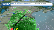
Clouds roll in Friday night as lows drop to the 20s again. Rain heads in for Saturday as an area of low pressure develops offshore and to our south. Southwestern Connecticut will see the showers first, then the rain spreads to the northeast by Saturday afternoon.
The rain will stick around all day for most of the northeast as temps reach the low 50s.
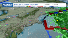
Sunday brings us more of an onshore flow so a few showers are possible and likely we deal with clouds and drizzle southeast, temps in the 40s and a raw feel to the day.
Weather
The exception will be in northwestern New England where you’re so far removed from the northeast flow you still manage to see some breaks of sun and highs in the mid 50s — Burlington, Vermont, for example.
Next week brings more of the same. A daily chance for showers, an onshore flow, cooler temps at the coast and more clouds. Waves of heavier rain can be expected as a system moves in midweek.
This could help change our pattern a bit. In the meantime, also plan on temps in the 40s at the coast to near 60 inland to start next week.
