
Puddles and mild air started the return to work and school coming off the holiday weekend Monday morning, though a new air whipping in on a busy northwest breeze will serve to both dry and cool the air.
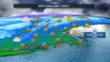
The drying happens quicker than the cooling, with early morning puddles shriveling under a blend of clouds and sun. Meanwhile, temperatures starting in the 50s gradually slide to around 50 degrees by midday, into the 40s by the time kids are headed home from school and even into the 30s north of the Massachusetts Turnpike by suppertime.
WATCH ANYTIME FOR FREE
Stream NBC10 Boston news for free, 24/7, wherever you are. |
Combine this with winds gusting to 35 mph at times, and wind chill values will drop squarely into the 30s by evening and into the teens overnight, when the wind eases a bit but temperatures bottom out in the 20s. On Cape Cod, the clash between chilly air aloft and relatively warm ocean water will mean some ocean-effect clouds Monday night, though little more than a sprinkle is anticipated to fall from those clouds.
Get updates on what's happening in Boston to your inbox. Sign up for our News Headlines newsletter.
Tuesday brings a fair sky and a nearly calm wind, though the cold start will likely cap afternoon high temperatures at 40-45 degrees, with clouds thickening late in the day and evening ahead of the next storm system. That next storm hasn’t taken shape as of this writing beyond a slug of atmospheric energy, associated clouds and a cold front over the Northern Plains. It's forecast, though, to organize and strengthen over the Midwest Tuesday, grabbing Gulf of Mexico moisture for an expanding area of rain over the eastern U.S., arriving to New England first as clouds Tuesday evening and night, then as rain on Wednesday.
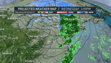
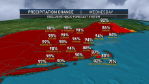
At this point, it looks like little more than an isolated shower will fall Wednesday morning, but Wednesday afternoon the rain fills in from west to east across New England, likely slowing the evening commute and lasting into the night. It’s the rain’s combination with an increasing south wind gusting 40-50 mph that’s prompted a First Alert from our weather team for Wednesday evening.
Although widespread damage wouldn’t occur from wind of this magnitude, widely scattered damage may. As the storm center crosses southern Canada, the attendant cold front swings through New England overnight Wednesday night, exiting the rain east of us by Thursday morning and bringing the magnitude of wind down an order, but still promoting a blustery wind Thursday with the return of cool air that likely will leave some lingering mountain snow showers in the North Country.
Cool and dry air continues with a quieting wind Friday, in a familiar pattern that will only serve to repeat yet again twice more in the 10-day forecast. Milder air arrives with showers by the latter half of Saturday into Saturday night, cooler and drier air follows Sunday and Monday, and mild air with raindrops yet again later Monday into Tuesday.


Each time, the chance of North Country mountain snow showers or snow bursts does increase as colder air streams back in, but right now a widespread snow event doesn’t seem to be in the cards. That said, the nights will continue to be excellent for manmade snow, so the ski area base will continue to grow thanks to the technology! The jet stream pattern is in the process of tipping colder for the first half of December, so the chances of accumulating snow, especially in northern New England, will rise, overall, as we get deeper into the new month.