
-

Forecast: Humid, isolated thunderstorms this afternoon
Today (Sunday): Partly Cloudy. Isolated Afternoon T-Storms. High: 83.
Overnight Tonight: Humid. Warm. Low: 70.
Monday: Hot & Humid. Evening Storms. High: 91.
Tuesday: Clouds & Few Showers. High: 80. -

Severe thunderstorms, flash flooding across New England
A flash flood warning has been issued in parts of southern Maine and southern New Hampshire, with severe thunderstorms widespread across the northern part of the region. See all severe weather alerts in your area here, and track interactive radar below: A weather system is swinging through New England Sunday, bringing clouds and an afternoon round of storms with some…
-

Forecast: No relief from heat, humidity Saturday
Tonight: Sct’d showers or storms, muggy, cloudy, lows in the mid 70s.
Saturday: Scattered showers and storms by late afternoon. Highs around 90, heat index mid 90s.
Sunday: Scattered showers and storms. Highs in the mid 80s.Follow NBC10 Boston:
https://instagram.com/nbc10boston
https://tiktok.com/@nbc10boston
https://facebook.com/NBC10Boston
https://twitter.com/NBC10Boston -

Forecast: Hot and humid into the weekend
Tonight: Sct’d showers or storms, muggy, cloudy, lows in the mid 70s.
Saturday: Scattered showers and storms by late afternoon. Highs around 90, heat index mid 90s.
Sunday: Scattered showers and storms. Highs in the mid 80s.Follow NBC10 Boston:
https://instagram.com/nbc10boston
https://tiktok.com/@nbc10boston
https://facebook.com/NBC10Boston
https://twitter.com/NBC10Boston -

Boston's weekend starts hot and humid, with afternoon storms
Friday night: Scattered showers or storms, muggy, cloudy, lows in the mid 70s. Saturday: Scattered showers and storms by late afternoon. Highs around 90, heat index mid 90s. Sunday: Scattered showers and storms. Highs in the mid 80s.
-

Severe thunderstorms flash across Mass.
Severe thunderstorm warnings have been issued Friday across Massachusetts, including in the Boston area, as well as in northern Connecticut. See all severe weather alerts in your area here, and explore live, interactive radar below: Another hot and humid afternoon is on tap as we find ourselves in the middle of a soupy, summertime airmass. Much of the region will...
-

Sticky, humid weather lingers in our region as week wraps up
Friday: Hazy, hot, humid. Highs in the low 90s, heat index 96-100. PM isolated storms.
Tonight: Sct’d showers or storms, muggy, cloudy, lows in the mid 70s.
Saturday: Scattered showers and storms by late afternoon. Highs around 90, heat index mid 90s.
Sunday: Scattered showers and storms. Highs in the mid 80s. -

Walden Pond's so full of water there's not much beach left
The beach at Walden Pond almost completely underwater — water levels are so high that even the park benches are submerged. And it might stay like that all summer.
-
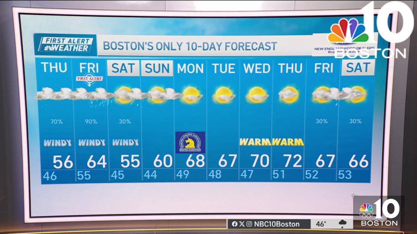
How long will the sun stay out in Boston?
Wednesday: Mostly Sunny to Partly Cloudy. Highs in the mid 50s. 60s inland. Wednesday night: Mostly cloudy. Scattered rain. Lows in the low 40s. Thursday: Scattered rain south. Highs in the mid 50s. Friday: Partly sunny. Highs around 60.
-
Less rain in the forecast as we go throughout the weekend
Friday: First Alert Day. Morning Fog and Rain. Isolated thunderstorm. Highs in the upper 50s.
Overnight Friday night: Clouds breaking. Breezy Winds: 20-25mph. Lows near 48 degrees.
Saturday: Partly Cloudy. Highs near 55 degrees.
Sunday: Mostly sunny. Evening Shower. Highs near 62 degrees. -
System to bring cool air, rain this weekend as it continues to move through northeast
A system continues to move through the northeast, bringing us some waves of rain through part of this weekend. Continuing Friday, the main line of heavy rain and wind has moved through Friday morning. We will see some clearing skies this afternoon while temperatures stay in the 60s and dewpoints remain soupy in the 50s. As a cold front...
-
Downpours and gusty winds strike Boston Friday
Friday: First Alert Day. Morning Fog and Rain. Isolated thunderstorm. Highs in the upper 50s.
Overnight Friday night: Clouds breaking. Breezy Winds: 20-25mph. Lows near 48 degrees.
Saturday: Partly Cloudy. Highs near 55 degrees.
Sunday: Mostly sunny. Evening Shower. Highs near 62 degrees. -
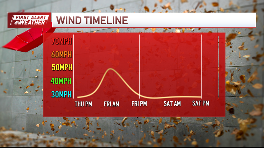
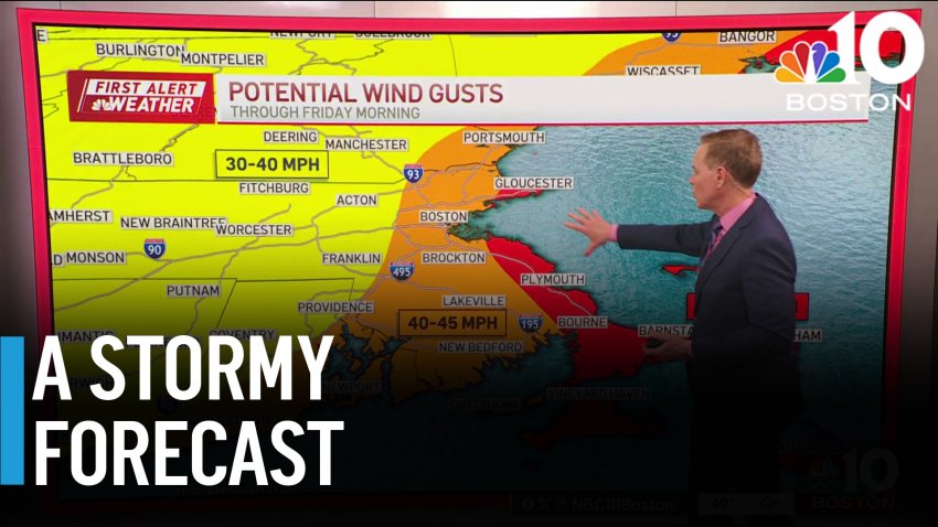
FIRST ALERT: Spring storm batters Mass. with heavy rain and strong winds, impacts morning commute
Bouts of heavy rain and strong winds will batter us Friday morning as the storm moves through. Gusts could top 40 miles per hour at times along the coast, and in isolated spots away from the coast (particularly the Worcester Hills). While the heaviest rain moves out after midday, the winds only ramp down to the 30 to 35 mph…
-
Downpours, gusty winds expected for morning commute
This Evening: Cloudy, showers return. Temps in the 50s. Overnight Tonight: Evening downpours. Brief wind gusts near 35mph. Lows in the upper 50s. Friday: First Alert Day. Morning Showers. Isolated Thunder. Highs near 60 degrees. Saturday: Scattered clouds mixed with sun. Highs near 56 degrees.
-
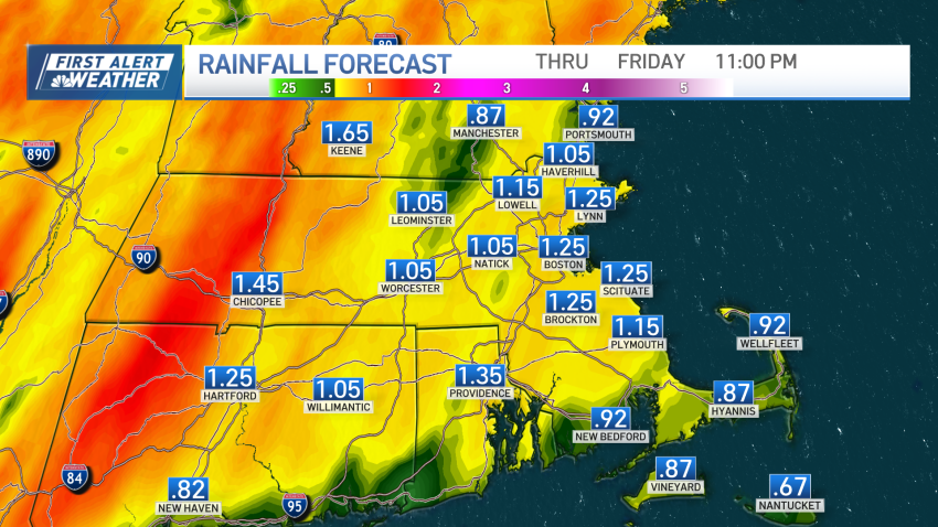
Heavy rain and strong wind gusts will close out workweek
We’re in a soggy stretch (again). While the temperatures remain mild, the rain is gathering strength to our south. We’ll see some batches of light rain cross overhead from time to time, especially around midday, as we await the heavy bursts after midnight. Temperatures are muted for much of the day, but as we get closer to the storm...
-
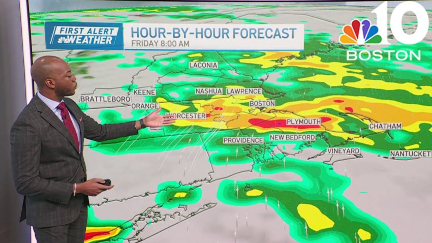
Weather forecast: Temps in the 50s, with periods of rain through Friday
Thursday: Partly cloudy. Scattered midday showers. Evening downpours. Highs near 56 degrees. Friday: First Alert. Morning downpours with pockets of lightning. Cloudy skies. Highs near 64 degrees. Saturday: Drying out, clouds clear through the day. Highs in the mid 50s.
-
Weather forecast: Windy with showers
Wednesday night: Scattered evening rain. Brief wind gusts near 20mph. Lows in the upper 40s. Thursday: Partly cloudy. Scattered midday showers. Evening downpours. Highs near 56 degrees. Friday: First Alert. Morning downpours with pockets of lightning. Cloudy skies. Highs near 64 degrees. Saturday: Drying out, clouds clear through the day. Highs in the mid 50s.
-

Cloudy with some leftover showers on Saturday
This isn’t the most stellar weekend, but then again, we don’t expect much from April. Clouds and a few showers will sweep through with our “old” nor’easter passing far off the Seashore. We’ll see brisk, chilly breezes throughout the day (so yes, there’s a bit of a wind chill factor). Highs struggle in the low and mid 40s all...
-
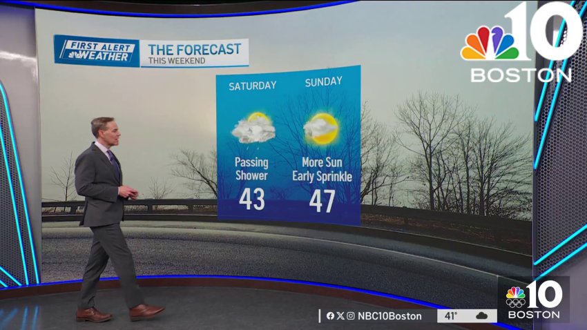
Forecast: Passing shower on Saturday
Overnight Tonight: Chilly air. Brisk Winds: 15-20mph. Lows in the mid 30s.
Saturday: Isolated coastal showers. Highs near 45 degrees.
Sunday: Partly Cloudy. Pockets of sun. Highs near 46 degrees.Follow NBC10 Boston on…
Instagram: instagram.com/nbc10boston
TikTok: tiktok.com/@nbc10boston
Facebook: facebook.com/NBC10Boston
X: twitter.com/NBC10Boston -

Forecast: Chilly, few flurries or sprinkles Friday night
This Evening: Cloudy skies, few flurries or sprinkles. Temps in the 40s....
...
Overnight Tonight: Chilly air. Brisk Winds: 15-20mph. Lows in the mid 30s....
Saturday: Isolated coastal showers. Highs near 45 degrees....
Sunday: Partly Cloudy. Pockets of sun. Highs near 46 degrees....Follow NBC10 Boston on…...
Instagram: instagram.com/nbc10boston...
TikTok: tiktok.com/@nbc10boston...
Facebook: facebook.com/NBC10Boston...
X:...
Trending