
The final days of 2022 are upon us, and the weather, although mild, is sliding. A weak weather system is expected to ripple through the area starting Saturday afternoon/evening and rolling through the night.
WATCH ANYTIME FOR FREE
Stream NBC10 Boston news for free, 24/7, wherever you are. |
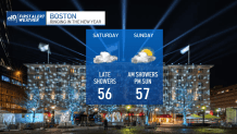
While we may be seeing the warmest NYE in 30 years with temps in the low 50s, it’s going to be tough to keep dry. The hope is (and at this point, it’s hard to promise anything because timing is so fickle) we could dodge some of the bands of steadier rain around midnight. The key to this is the fact that the storm system is NOT producing relentless rain or downpours; all the precipitation seems intermittent and spotty in coverage.
Get updates on what's happening in Boston to your inbox. Sign up for our News Headlines newsletter.
Some of that warmth lingers into daybreak New Year’s Day. The high temps should be reached late morning and early afternoon before we see a slight drop later in the day. All told, temps hover in the mid and upper 50s (again). Winds will turn to the northwest, so after the last morning showers move through, some sun is possible from time to time. Pats and Dolphins game should be breezy and dry.
Monday’s the “cool” day as we fall back to the upper 40s for the Winter Classic at Fenway under sunny skies, then surge ahead into more warmth from Tuesday-Thursday. This next spat of mild air comes with rain, but it also harbors some big numbers. Our guidance is already tagging us with LOW 60s for Wednesday – despite the wet weather throughout the day!


Enjoy the year-end festivities, be safe and PLEASE DON’T drink & drive!