While New England enjoys a brief midweek thaw, this time of the year chances are good that more wintry weather is just around the corner, and we’ll find no exception this week.
For now, New England finds ourselves on the warm side of a developing storm system – an intense bundle of energy traversing the nation’s midsection and strengthening on a combination of Gulf of Mexico warmth and moisture and the clash with intense Canadian cold pushing into the Northern Tier of the U.S., resulting in a sharp cold front pushing southeast into the Ohio Valley.
WATCH ANYTIME FOR FREE
Stream NBC10 Boston news for free, 24/7, wherever you are. |
This cold front will be critical to the forecast details in the days ahead, marking a sharp change from raindrops and 40s to snowflakes and 20s, expected to very slowly trudge south across New England Thursday into Friday. Between now and then, the milder temperatures will bring enough melting that snow still on roads, walkways and driveways becomes slushy and sloppy, though the re-freezing we’ve seen in the past several nights is unlikely for most of us Wednesday night with temperatures remaining above freezing after a daytime high around 40 for all but far northern New England.
The arrival of milder air will be marked by an abundance of clouds Wednesday through Wednesday night, though raindrops will likely remain rather limited, with some sprinkles or light showers in southeast New England Wednesday midday and afternoon.
Get updates on what's happening in Boston to your inbox. Sign up for our News Headlines newsletter.
Otherwise, Thursday brings the advance of steadier precipitation as the storm system to our west draws closer, spreading mixed snow and rain showers in northern and western New England first, then expanding as rain for the rest of us during the morning to midday Thursday, arriving last to Cape Cod during the afternoon.
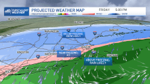
As the approaching, well-defined cold front arrives to New England, it will slow considerably but also will clearly mark the start of a north wind and a colder air, turning all of northern New England to snow by late Thursday, and introducing some sleet and freezing rain into central New England before a turn to snow overnight Thursday night.
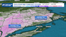
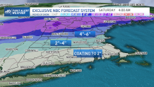
There’s a lot of Gulf of Mexico moisture with this system, so even after the change to snow, enough precipitation falls for a 12 to 18 inch snowfall in the northern mountains with a widespread 8 to 12 inches for most of northern New England.
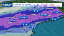
The farther south one is, the longer it takes for the slow-moving cold front to arrive Thursday night and Friday, and the less precipitation that falls as snow before it shuts down Friday evening. Nonetheless, enough snow should fall for a coating to two inches even in some far southern communities of New England, with amounts expected to gradually increase with northern extent.
The timing of the cold front is crucial, as it will mean temperatures drop below freezing from north to south in southern New England Friday, resulting in freezing of water on some roads.
Weather Stories


As the storm center continues east and moisture pulls out Friday evening, the mess comes to an end, and cold, dry air settles into New England for both weekend days with a busier wind Saturday than Sunday.
Next week, there are no days that jump out as storm-makers, but the jet stream pattern really does favor potential storm development and our exclusive NBC Forecast System indicates a higher chance of precipitation on both Tuesday and Friday, so we’ll be keeping a close eye in our 10-day forecast.