Extremes defined the weekend across New England. Record-setting warmth, then a half foot of snow? Both were hard for the models to handle, and some spots received more snow than we were thinking. Every time it seemed that the snow would end, another band filled in right behind it.
All of this was a result of a stalled boundary that was aided and abetted by ocean-effect snow. The last bits are pulling out early this morning as we await the return of the sun later in the day.
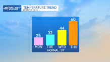
Cleanup will be hampered by a steady breeze and wind chills that remain in the single digits. Cold reinforcements are piling on too, keeping our high temperatures in the low 20s. Dress for the former, however. It’s clearly winter mode again.
Get Boston local news, weather forecasts, lifestyle and entertainment stories to your inbox. Sign up for NBC Boston’s newsletters.
But it won’t stay that way. Already we’re seeing signs that the 60s want to make another run for New England. The cold will be reluctant to go in the first half of the week, so don’t look for any movement through tomorrow, but with a wind shift and some sun on the way for Wednesday, we’ll boot the cold and bring in the warmer weather. Thursday should peak in the upper 50s to near 60, then rain and another front will send temperatures spiraling down during the day on Friday.
Long range, it looks like the cold won’t be as intense after the warmup. Is spring really getting a foothold? In this pattern, we certainly won’t count out winter just yet.