A powerful storm system moved into New England Wednesday, sparking severe thunderstorm warnings across the northern half of the region and in western Massachusetts.
A severe thunderstorm warning was in place for parts of Massachusetts Wednesday evening, after much of New England was under severe thunderstorm watches. A tornado warning was issued at one point in southern Maine. The alerts have since expired.
The severe weather was expected until sunset, generated by cool air pressing south from Canada as a summer wind blew in from the south in much of central and southern New England.
This meant “triple H weather” was back -- hot, hazy and humid conditions took over in the afternoon, but it won’t be for too long.
Get Boston local news, weather forecasts, lifestyle and entertainment stories to your inbox. Sign up for NBC Boston’s newsletters.
Thunderstorms moving out of New York are passing through central New England with damaging wind gusts in excess of 60 mph and hail larger than 1 inch, along with torrential downpours.
The heaviest weather was estimated to appear from about Rutland, Vermont, to Bangor, Maine, slowly shifting southward. That's because the front is slowly moving towards the south. Showers and thunderstorms are moving in and dissipating over northern Massachusetts as the sun goes down.
Our atmosphere will likely have low-level shear, which means it could feed off spinning along these thunderstorms. In other words, the atmospheric combination of having warm and humid air and an incoming front will be an advantage for the storms’ development.
Weather Stories


It was one of those afternoons where we recommend people stay at home and weather alert.
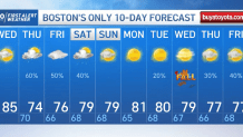
A cold front will help us come back to the 70s as soon as Thursday.
We will likely watch for showers in the overnight hours in Connecticut, Rhode Island and Cape Cod, but the severe storm potential will be mainly focused across northwest and western Massachusetts and into areas of New Hampshire and Vermont.
Along with a temperature decrease and cooler air incoming for Thursday, the weather pattern rapidly changes. The parts of New England that have the worst weather Wednesday get the best weather Thursday, with sunshine returning for much of northern New England and highs in the upper 60s lower 70s.
An incoming low pressure from the south will allow for more moisture to come in, along with an increase in rain chances, which will remain in place until Friday and early Saturday. This low pressure system has a high probability of becoming a tropical depression between today and tomorrow.
Meanwhile, tropical depression Nicholas continues to provide concerning amounts of rainfall with the elevated risk of flooding across the southern states of Louisiana, Mississippi, Alabama and Georgia.