Well, it could be worse. We could be looking at nonstop rain through the holiday weekend. Temps could hold in the 50s every day. And it could be….snowing.
Ok, maybe not.
WATCH ANYTIME FOR FREE
Stream NBC10 Boston news for free, 24/7, wherever you are. |
Rain from last night is on its way out, but it will leave behind heaps of clouds. All the while, the cooler air will continue to seep in through the day. Our morning highs will hover around the upper 60s, but by day’s end, the temps fall to the upper 50s to low 60s. It’s a recipe for long sleeves and perhaps a sweatshirt if you’re heading out this evening. Yes, I just typed that.

Get updates on what's happening in Boston to your inbox. Sign up for our News Headlines newsletter.
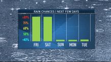
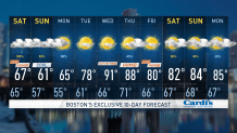
The rest of the weekend will see a smaller storm system spin up overhead. This means a return to the showers, but not the heavy rain of last night. It keeps Saturday in the gloom, and keeps the temperatures from getting out of the 50s (again not a typo) for much of the day. If Boston is 61 or below, we will tie/break a record COLD high temperature (yes, it is a thing) for the date. Hard to believe we were 100 degrees two days ago.
Ironically in all this wet weather, the evening forecasts still seem OK. The showers break for a few hours, and Sunday night will actually partially clear out. It’s the temps that will disappoint - 50s both Friday and Saturday evening, low 60s Sunday evening for cookouts and fireworks displays.

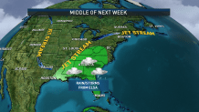
The pattern gets back to summer next week. Many have Monday off, and the forecast is nudging 80 in many spots with plenty of sun. Then Tuesday it’s back to a brief foray in the 90s. The latter half of the 10 day is up in the air. Admittedly, it’s often on shaky ground in times of transition, but this time it’s more uncertain because of Tropical Storm Elsa.
If the storm were to be in the vicinity of Florida early next week, its remnants may get pulled in our direction later next week. Timing is all awry with this feature, and the medium range models are having a hard time even finding the circulation after Tuesday. So, we’ll wait for the details to get sorted out.
In the meantime, make the best of the holiday weekend, be safe, and don’t curse out the meteorologists on social media.


