
While the Sun stays in hiding, the temperature keep climbing. Highs yesterday managed to make it to the mid-30s, but with a milder airmass flooding the region, we have a two-day stand of 40+ coming.
What’s more is the melting at night. Temperature should stay above freezing in many spots overnight and into tomorrow. With such a dense, cold snowpack, there WILL be exceptions to this, so beware of any refreeze tonight.
Along with the clouds will come the fog tomorrow. Fog is a very efficient snow eater, so this will knock back the snow banks, squash the drifts and chew away at the snow in the yard. While we’re not expecting the snow to vanish completely, this will put a sizable dent in it.
Get Boston local news, weather forecasts, lifestyle and entertainment stories to your inbox. Sign up for NBC Boston’s newsletters.
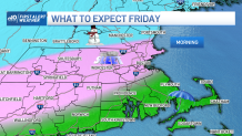
Our main focus in the coming days is on a cold front approaching New England. Initially, many of us will see rain starting on Thursday morning. Then we’ll turn to ice late Thursday night, and continue as ice for much of Friday.
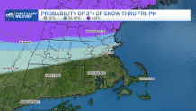
What about replenishing the snowpack? There is a changeover on Friday from ice to snow, but it appears there may not be a great deal since the storm will be ending by the time we completely switch to snow. This has been the trickiest part of the forecast, however, so we’re watching this closely.
A faster changeover will (obviously) mean more snow, but I’m just not sold on the idea of flushing out the layer of mid-level warmth that quickly. Typically, it takes a little bit longer than the models suggest to complete the changeover.
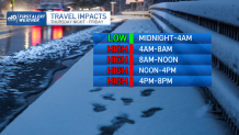
In any event, the concern revolves around the spat of icing on Friday. We’re expecting plenty of slick spots throughout the day and for BOTH commutes. This is mostly the “bouncing” ice (sleet), however, without much glaze. Nevertheless, be careful driving and walking anywhere on Friday.
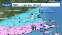
This colder air rushing in Friday also means the melt/rainwater will be refreezing. This will create quite a mess around the region into Friday night as the temperatures plummet to the upper teens and low 20s. Nothing good comes out of an icing situation, but this is just adding insult to injury.
Weather Stories


We’ll be fine tuning the forecast through the storm. Stay with us for updates.
