Showers will become more numerous this evening as a weak area of low pressure passes south of the region. Not much is expected in the way of rain, anywhere between 0.10” to about .25”, with the highest amounts along the south coast of New England.
Showers will slowly shut down from west to east overnight with a few wet snow flakes mixing in across the higher elevations, but not enough to substantially accumulate on the ground.
Sign up for our Breaking newsletter to get the most urgent news stories in your inbox.
Expect patches of black ice from tonight into early morning, with temperatures dipping down to freezing. Lows tonight drop into the 30s south, near freezing inland, upper 20s to low 30s north.
Get Boston local news, weather forecasts, lifestyle and entertainment stories to your inbox. Sign up for NBC Boston’s newsletters.
A wedge of high pressure builds into New England as the new work week starts, delivering dry and mild conditions right through Tuesday.
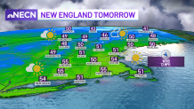
High temperatures on Monday will be mostly in the mid to upper 50s south, 40s north with a few clouds around. Tuesday is shaping out to be the pick of the week as temperatures approach 60 degrees across portions of southern New England, though we may have to deal with cooler temps along the immediate coastline as localized sea breezes kick in.
Late Tuesday night, showers will develop as low pressure exits the south and moves up the eastern seaboard. Wednesday looks wet for much of southern and central New England, with northern areas appearing to be spared.
Another system on its heels will bring widespread rain to the region, perhaps some wintry precipitation in far northern areas on Thursday into early Friday. An upper level system looks to keep things a bit unsettled Friday into the first portion of the weekend, but accurate projections will be determined throughout the week.