
We’ve been spared by frigid temperatures the last couple of weeks, but our luck has finally run out! The calendar shows Jan. 3 on it and today will feel like January.
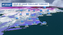
Temperatures will be very cold across all of New England along with bitter cold wind chills! It will be a shock to the system for sure, so grab those winter jackets, hats, and gloves.
High temps will only reach the teens and low 20s north, 20s to low 30s south. A gusty northerly wind will bring wind chill values down into the single digits north, teens south!
Get Boston local news, weather forecasts, lifestyle and entertainment stories to your inbox. Sign up for NBC Boston’s newsletters.
Much of the region will remain dry today with some high, thin clouds dimming out the sun north. We’ll see more clouds south as a large, developing ocean storm passes well south of New England.
Much of its precipitation will stay out to sea, but southeastern New England will be on the northern fringe of its precipitation shield. With cold air in place, we will see a period of snow. The best chance for accumulating snow will be across the Cape and the Islands, where we could see several inches by Monday evening.
The Islands, especially Nantucket may see up to 5” of snow. The snow will start around or just after 8 a.m. and continue through this evening before tapering off.
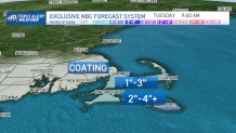
Along with the snow, we will see gusty winds across the Cape, which will likely reduce visibilities. If the storm track shifts to the south, all bets are off and we end up with flurries and perhaps a coating. If it shifts a bit more north, then we could see more snow. Our First Alert Team will be monitoring this event every step of the way!
The snow isn’t the only thing we’re monitoring today. Due to the astronomical high tides today in conjunction with gusty northerly winds, we could see some minor issues during the late morning/early afternoon high tide cycle.
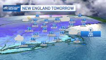
After a seasonably cold day Tuesday with a good deal of sunshine, temperatures Wednesday will moderate into the 40s as another system passes through the region bringing more rain/snow showers.
Weather Stories


A more important storm may bring a widespread snowfall, perhaps a mix near the coast, Thursday night and Friday! We’ll be keeping an eye on it for you! Have a great day!
