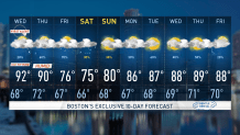
The triple “H” is back, Hazy, Hot, and Humid today and tomorrow.
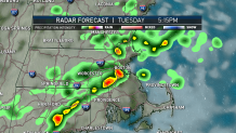
Today we are watching the potential for severe thunderstorms this afternoon. Some of these are expected to be strong to severe. Main threat is the damaging wind along with heavy rain.
WATCH ANYTIME FOR FREE
Stream NBC10 Boston news for free, 24/7, wherever you are. |
Along with this severe potential comes the heat and humidity. Temperatures today will be in the lower 90s with dewpoints in the uppers 60s to around 70. This oppressive humidity will “stick” around through Wednesday. The window for this unsettled weather this after is between 1 p.m. to 8 p.m.
Get updates on what's happening in Boston to your inbox. Sign up for our News Headlines newsletter.
Tomorrow will be another hot and humid day with scattered afternoon showers and thunderstorms. We’re, once again, expecting heat indices to approach the high 90s.
A cold front is expected to stall south of the area Thursday and Friday with showers and thunderstorms. Thursday overnight into Friday is when Elsa is expected to track south of New England, enhancing the rain and churning up the waters with high surf.
By late Friday into Saturday, the front will move through then stall to our south. We may see more scattered showers and thunderstorms cruise along the front.
Remember to stay hydrated in this hot weather, check on your neighbors and never leave pets or children unattended in your car - they can heat up quickly. Stay safe.