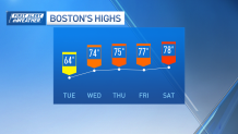
A pleasant warmup is coming our way in the First Alert forecast as high pressure takes control from the middle of the week through the weekend.
We begin that warmup today, as highs rise to the mid-60s. Those highs jump into the upper 60s to middle 70s by Wednesday. Our temperatures will be a few degrees above where they landed yesterday too; expect highs generally 60-65 regionwide. Frost overnight won’t be nearly as widespread as this morning either – with lows in the 40s and lower 50s except for the coolest valleys and far northern New England which will dip into the mid to upper 30s. Waking up to clear conditions tomorrow but clouds build through the day.

Thursday and Friday will be well into the 70s again, and an 80-degree reading can’t be ruled out in a few communities on Friday or Saturday afternoon! Records to beat in Boston are 85 and 81 on Friday and Saturday respectively, so we’ll come close but probably fall shy of those in the city.
Get Boston local news, weather forecasts, lifestyle and entertainment stories to your inbox. Sign up for NBC Boston’s newsletters.
A cold front heads our way by the second half of the weekend. While a few showers are likely for Sunday afternoon and evening, many of us will stay dry. We start the transition back to cooler air on Sunday as that front approaches.
Some showers are likely to linger into Monday, though it doesn’t look like a pouring rain. A few spotty showers are possible on Halloween, although it looks like they’ll be isolated and brief, so trick-or-treaters shouldn’t have to worry about carrying an umbrella or altering costumes at this point. Below-average temperatures, around 50 will kick off the month of November as seen in our exclusive 10-day forecast.
Be prepared for your day and week ahead. Sign up for our weather newsletter.

