The warmup starts today! Temperatures crawl at first this morning, then get some traction in the afternoon. Truth be told, the warmup will stretch into the night - and then level off late - as the south winds continue to pump in the milder air.
We’ll be pushing the limits tomorrow. Record to beat is 61 in Boston and 56 in Worcester. Oddly, Worcester has the better chance simply due to the fact that the south wind will be coming off of cold water through Narragansett Bay, up I-95 and into Boston.
Essentially, all points in eastern Massachusetts will be “contaminated” by this cool wind, and it will be harder to break the 60 degree barrier….at least tomorrow. Friday has a better chance since the airmass will be a tad warmer and the winds will be more from the southwest.

Get Boston local news, weather forecasts, lifestyle and entertainment stories to your inbox. Sign up for NBC Boston’s newsletters.
The warmer air is fleeting on Friday. We’re seeing the cold front cross by mid-morning, and the chilly air will start funneling in quickly. By evening, we’ll see temperatures back down to seasonable levels in the 30s.
Clouds will be swarming in the afternoon, and streaming overhead (watch how quickly they move) through Thursday and into early Friday. Rain should hold back until late Thursday and the early hours of Friday morning. Brief downpours are also possible in that time frame.
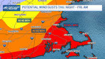
Wind is the bigger issue with the storm system. Gusts today should stay capped at 30 mph late. More is expected tomorrow and tomorrow night, with frequent gusts to 40. The peak winds come as the front crosses Friday morning.
Weather Stories


Some spots in eastern Massachusetts – and the higher terrain of Worcester County and southwest New Hampshire – will see winds top out at 50-55 mph with the Cape and Islands near 60! This comes right during the morning ride, so there might be some small limbs in the streets and highways on the way to work and school. In addition, there may also be isolated power outages.
Hang on and stay in touch. We’ll have you covered through the storm.