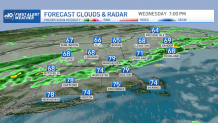
Northern New England, hit so hard by severe weather Wednesday, is enjoying the best weather on Thursday.
High pressure in Canada pushed the storm-generating cold front to the South Coast of New England, where heavy weather Thursday morning caused some damage from Buzzards Bay to Cape Cod. Clouds and a few showers are lingering south, with beautiful blue skies and low humidity north.
It is much cooler to the south on Thursday with an onshore flow -- 60s at the shore to 70s inland and north.
Get Boston local news, weather forecasts, lifestyle and entertainment stories to your inbox. Sign up for NBC Boston’s newsletters.
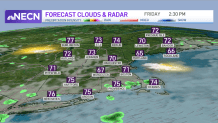
Overnight, high pressure noses into New England, continuing mostly dry conditions, aside from some spotty light drizzle that develops. Low clouds will be around, with temperatures dropping down into the low to mid 60s.
Clouds will stick around through Friday, aside from a few peeks of sun, with the threat of a brief shower. We're expecting a dry day overall, with highs rising into the 70s with an increased humid feeling to the air.
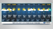
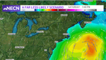
A coastal low pressure or tropical cyclone will pass east of the region on Saturday, bringing rough surf and rip currents to the coast. Improving cloud cover is expected, with scattered showers around with highs rising into the mid to upper 70s.
Sunday features a weak cold frontal passage with partly sunny skies and high temperatures in the low to mid 70s, upper 70s in the Connecticut River and Merrimack Valley and 60s in northern Maine.
A pleasant stretch of dry and warm weather into next week is on our First Alert Weather 10-Day Forecast.